• IP addresses are NOT logged in this forum so there's no point asking. Please note that this forum is full of homophobes, racists, lunatics, schizophrenics & absolute nut jobs with a smattering of geniuses, Chinese chauvinists, Moderate Muslims and last but not least a couple of "know-it-alls" constantly sprouting their dubious wisdom. If you believe that content generated by unsavory characters might cause you offense PLEASE LEAVE NOW! Sammyboy Admin and Staff are not responsible for your hurt feelings should you choose to read any of the content here.

    The OTHER forum is HERE so please stop asking.

If you don't hear from me again, it was good while it lasted

Faidenk

Alfrescian
Loyal
Singaporeans don't know how lucky they are. All they get is a bit of ponding and the occasional delay in MRT services.

Thanks to the PAP, there is hardly a thing to worry about on that beautiful island.


Someone in Singapore is always worried about fixing the opposition. With idiots like these, what me worry?
 

Leongsam

High Order Twit / Low SES subject
Admin
Asset
Eight destructive New Zealand storms

http://www.nzherald.co.nz/nz/news/article.cfm?c_id=1&objectid=11219710

By Marilynn McLachlan


4:00 PM Friday Mar 14, 2014


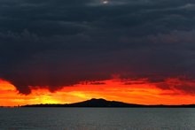
With Cyclone Lusi expected to hit tomorrow morning, we look back on eight powerful storms that caused loss of life, destruction and millions of dollars' worth of damage.


1 Great Storm 1936

Largely forgotten, this storm began as a tropical cyclone that on January 28, south of the Solomon Islands before traveling southeast and meeting a cold front, intensifying and hitting the North Island on February 1.
It brought with it heavy rains, causing every major river in the North Island to flood. Buildings were destroyed from Picton to Kaitaia, footpaths were ripped up, thousands of trees were brought down, power was lost and roads and railway lines were cut in hundreds of places. There was flash flooding and thousands of cattle and sheep were drowned. In Auckland, 40 boats were sunk or driven ashore. 10 people lost their lives.


2. Cyclone Gisele 1968

Building near the Solomon Islands on April 5, warnings were issued throughout New Zealand, despite it being hundreds of kilometres away. Hitting Northland on April 9, it swept down the North Island with torrential rains causing flooding, landslides, and the destruction of buildings.
Colliding with a polar storm, it swept into the capital city on April 10 and the winds reached 275 kilometres per hour - the strongest ever recorded by the New Zealand Meteorological Service. A young girl was killed and her sister injured when iron from a nearby roof blew through their bedroom window. Another man died after being knocked over by the wind.

The storm also caused New Zealand's worst modern maritime disaster - the sinking of the Wahine. As it crossed the Cook Straight, gale force winds and large waves rocked the ferry and as it moved into the shallow harbour, she lost radio contact and was unable to gain her bearings. After an hour and a half, she struck Barrett's Reef and sunk seven hours later.

3 people died as a direct result of the cyclone. 51 people were killed in the Wahine disaster.


3. Windstorm 1975

Nicknamed The Big Blow, hurricane-force winds swept over Canterbury, with gusts reaching 195 kilometres an hour. Thousands of hectares of pine forests were destroyed, roofs were blown off buildings, aircraft were damaged and there were many electrical fires caused by falling powerlines.

4. Cyclone Bola 1988

Forming on February 24, Cyclone Bola struck the Hawke's Bay and Gisborne on 4 March 1988. Its torrential rains, which fell for three days, and strong winds caused flooding, damage to housing and the destruction of roads and railway lines. There were many landslides and farmers lost large portions of their pastures and orchards. Thousands of people were evacuated from their homes.
Three people died when their car was swept away by flood waters.

5. North Island Weather Bomb 2008

Three storms hit the North Island in a three week period in July 2008. Bringing with it high winds and heavy rain, it caused power cuts, flooding and damage to trees and buildings.
Three people drowned in the Bay of Plenty.

6. Ex-tropical Cyclone Fergus 1996

Forming in the Solomon Islands, on 28 February, Cyclone Fergus travelled across the Pacific in a loop before heading south towards New Zealand, hitting the North Island on 30 December. It brought with it heavy rains, flooding, landslides and high winds and caused havoc to hundreds of holiday makers who had to seek shelter in Civil Defence centres. There was major road damage, power cuts and flooding. Surf life guards rescued nine motorists trapped in three cars in Pauanui, getting them to safety in inflatable boats.
It caused significant damage and a Civil Defense Emergency was declared in some areas,
Two people died - one in Northland and another in Thames.


7. Ex-tropical Cyclone Drena 1997

Just two weeks after Cyclone Fergus hit New Zealand, a tropical cyclone formed in the Pacific, peaking in intensity on 6 January. It hit New Zealand on 10 January. As it hit the upper North Island, it brought high winds and seas, causing damage to property - including roofs that were lifted. It travelled south towards central New Zealand and damaged roads and property, brought down trees and destroyed agriculture.
In Auckland, boats were damaged and cars were blown across lanes. Over a hundred people were evacuated from their homes, roads were closed, and thousands were without power. The South Island also suffered strong winds and heavy rains and flooding.

Three people died, including a man hit by falling power lines and a couple who were swept away in a car.

8. Cyclone Wilma 2011

Travelling across the North Island on January 28-29 , Cyclone Wilma brought with it heavy rains and winds, causing severe flooding, road closures and landslides. The heavy rains caused sewage to spill into the water of some of Auckland's beaches, caused destruction to houses and many evacuations.

While there were no deaths as a direct result of the cyclone, there were many dramatic rescues. On Waiheke Island, two women were woken by their dog barking and managed to escape their bach before it plunged 30 metres off a cliff onto the beach at Onetangi. In Clevedon, a doctor travelled across floodwaters in a kayak to reach a woman in labour. She was airlifted to hospital and gave birth later the same day. Firefighters used a boat to rescue two people who were stuck up trees in Pipiwai, as well as rescuing a family of two adults and two children trapped in a house in Kaeo.

By Marilynn McLachlan
Copyright ©2014, APN Holdings NZ Limited
 

Leongsam

High Order Twit / Low SES subject
Admin
Asset
hahahaha :biggrin: You sure it was 1000? I thought it was 700?!?

Stop worrying lah! You will be ALIVE and KICKING! :biggrin:

Even if I survive the weekend, from next week onwards, I'll have to start worrying about the volcano in my backyard.

printLogo.png


Rangitoto's blasts from the past

By Jamie Morton @Jamienzherald
5:30 AM Friday Apr 12, 2013
SCCZEN_A_250407NZHBPSUNSET2_220x147.jpg

Rangitoto is older than previously believed. Photo / Brett Phibbs


Rangitoto may be much older - and more explosive - than previously believed.

A new study has led scientists to reassess how volcanoes may behave in the future and could be a large step toward unlocking Auckland's mysterious volcanic past.

Contrary to the long-held belief that Rangitoto was formed less than 700 years ago and has erupted only twice, University of Auckland researchers now suspect there may have been intermittent activity from between 1500 years ago to 500 years ago.

Alongside basaltic ash from the island volcano's most recent eruption between 500 and 550 years ago, sediment samples taken from Lake Pupuke have revealed evidence of minor eruptions 922 years ago, 1040 years ago and 1500 years ago.

"That's much longer than we've traditionally believed for basaltic volcanoes of this kind, not only in Auckland but anywhere in the world," said lead researcher, Associate Professor Phil Shane.

The findings, published in the Journal of Volcanology and Geothermal Research, were important for understanding the risk posed by volcanoes in the Auckland region - and perhaps elsewhere, Dr Shane said.

"The old paradigm was that these volcanoes erupt suddenly in a new location each time, and only live for months to a year or two. This needs to be revisited in light of the new Rangitoto history of activity."

Future long-lived activity was a possibility, either at Rangitoto or at other eruption sites across the Auckland Volcanic Field, home to more than 50 volcanoes.

"We cannot rule out long-lived activity in the future, or eruptions at sites that have experienced previous activity," Dr Shane said. "The Auckland volcanic field could be going into a new mode of operation. If so we need to think about hazard planning and risk in a very different way."

The new study is part of an ongoing research project into the history of volcanic eruptions and lakes in the Auckland region involving Dr Shane, Associate Professor Paul Augustinus and PhD student Ola Zawalna-Geer.

The largest and most recently active of Auckland's volcanoes, 260m-high Rangitoto has long proven an enigma for scientists trying to unravel what eruptions have occurred in Auckland. More importantly, it may be the key to understanding where the next blow might take place.

Rangitoto's most recent eruption, between 500 to 550 years ago, happened near the site of the field's oldest eruption, Lake Pupuke, leaving no obvious northward or southward trend to draw a pattern from.

Scientists believe the answer to Rangitoto's riddle is that either its activity was an anomaly and had now ceased, that the field's activity has now moved to Rangitoto, or that future eruptions may occur at Rangitoto and elsewhere in the field for the next 500,000 years.

Unfortunately, the new study did not solve the puzzle, said University of Auckland volcanologist Dr Jan Lindsay.

"Will it continue erupting in 500 years' time, will the activity switch somewhere else, or will it occur in connection to activity somewhere else? We don't know."

When and wherever the next eruption does come, Civil Defence planners believe sufficient warning time would result in no casualties, with even a three-day lead-up providing plenty of time for evacuation.

Research by Market Economics estimated that in a worst-case eruption near the CBD, the Auckland region could suffer a 47 per cent reduction in gross domestic product.

But this could be reduced by 40 per cent if businesses had effective preparedness measures in place.

New Zealand would suffer a 14 per cent decline in GDP. However, relocated business could bring about a 3 per cent rise in GDP in the rest of the country.
VolcanoesSecretsApr13.gif

By Jamie Morton @Jamienzherald
- NZ Herald

Copyright ©2014, APN Holdings NZ Limited


AhMeng

Alfrescian (Inf- Comp)
Asset
Just come back to your other BACKYARD....Sinkapore.

Sinkapore, the city built from scratch by LKY and the PAP...the city that you grew up!
Come back and get screwed together by the PAP!
 

escher

Alfrescian (Inf)
Asset
The wind is picking up steadily..... the sky has turned grey and threatening.... pressure has dropped and humidity has increased.

The neighbors are busy boarding up their windows and putting away their outdoor furniture. Sandbags are being filled throughout the neighborhood. Those with diesel generators have just fired them up to make sure they work.

This looks very bad. Because I spend so much time taking care of this forum, I have done no preparation whatsoever. The only measures I have taken have been to present offerings to Nāga.

I can't help feeling that the end is near. :*:


REPENT REPENT

You wasted your chance in singing hosannas to that smear of shit on sole of shoe LKY.

YOU SHOULD HAVE BEEN MORE DILIGENT LOOKING FOR THAT METAL SHIT BUCKET THAT 50 BANGLA FAMILIES CAN SHIT INTO.
YOU CAN TAKE COVER IN THERE

Now is too late

REPENT REPENT REPENT

And in your next reincarnation you can become a tampon used by Ho Ching
 

escher

Alfrescian (Inf)
Asset
I give you 1000 rep points plus promote you and you curse me in return???

Should you gimme 1000 points, I never ever will curse you.

I will be concerned about you and your health.
I will remind you to take your medications when ever you show by your hosannas that you lost your mind.

When you are raving, I will very solicitously remind you to cool your brain below liquid line of a metal bucket.

Your gift of a thousand points to me will bring you good karma and ensure your reincarnation as a tampon HC will use.
 

eatshitndie

Alfrescian (Inf)
Asset
due to the earth's west-east rotation and typical east-west direction of cyclones, hurricanes, typhoons (they are all the same thingie) from huge bodies of water such as oceans, major storms of such kinds tend to smash into the eastern seaboard of any land mass: e.g. atlantic coast including florida, east asian coastlines including japan, korea, china, taiwan, hong kong, vietnam, philippines, bengal and eastern coastline of india, etc.

my advice for anyone emigrating to a foreign cuntry is to go west or a coast on the west side of the land mass. not only do you tend to get a mediterranean-type climate, thus avoiding extreme humidity in summer especially in the northern hemisphere, you are also spared from suffering the destructive effects of a potentially earth-shattering category 5 hurricane-like event. sg is spared from such fun events because she is sheltered among the indon-malasian archipelago with no wide open oceans to generate such storms and the seas on her eastern shore are punctured with islands and a huge sub-continent-sized land mass by the name of borneo.

there are exceptions. hurricanes which started in the gulf of mexico do occasionally cross over the thin land bridge between the north and south american continents and swing around and hit baja california, which is part of mexico on her western seaboard.

eatshitndie reporting great weather in the bay area. :biggrin:

correction: "advise" to "advice." typo. :p
 
Last edited:

Leongsam

High Order Twit / Low SES subject
Admin
Asset
Cyclone Lusi: North Island feels sting

By Rebecca Quilliam, The Herald Online


Strong winds drop power lines and a tree as storm begins trek down country.

<figure style="margin: 0px; padding: 0px; border: 0px; outline: rgb(0, 0, 0); vertical-align: baseline; background-color: transparent; -webkit-transition: color 0.2s, background-color, border-color, opacity; transition: color 0.2s, background-color, border-color, opacity;">
rbakerrussell4_620x310.jpg
</figure><figcaption class="caption" style="margin: 0px 0px 5px; padding: 10px 0px; border-width: 0px 0px 1px; border-bottom-style: dashed; border-bottom-color: rgb(204, 204, 204); outline: rgb(0, 0, 0); font-size: 13px; vertical-align: baseline; background-color: transparent; -webkit-transition: color 0.2s, background-color, border-color, opacity; transition: color 0.2s, background-color, border-color, opacity; color: rgb(102, 102, 102); line-height: 17px;">The Storm Surge coming over the banks and onto the roads in the Bay of Islands. Photo / Rita & Geoff Baker</figcaption>
Residents at the top of the North Island are starting to feel ex tropical Cyclone Lusi sting with gales hurling a shed through powerlines, slips, treacherous driving conditions and thousands without power.

Strong easterly winds gusting to 120km/h blew a shed through power lines at Whangarei Heads overnight, cutting power to 2000 homes a Northpower spokesman said.
You can track Cyclone Lusi in real time here.

Residents affected were in towns along the east coast.

As the storm tracked south today conditions across Auckland were deteriorating.

<figure class="inlineMedia inlineMedia-inline-gallery inlineMedia-right inlineMedia-width300" style="margin: 0px 0px 12px 16px; padding: 0px; border: 0px; outline: rgb(0, 0, 0); vertical-align: baseline; background-color: transparent; -webkit-transition: color 0.2s, background-color, border-color, opacity; transition: color 0.2s, background-color, border-color, opacity; clear: both; float: right; position: relative; width: 300px; max-width: 620px;"> 
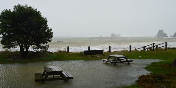
Gallery</figure>Electricity company Vector said some customers in Wellsford, Hobsonville, Kaipara and Waiheke Island were still without power.

The outages had mainly been caused by downed trees and crews were working to clear the lines, the company said.
Stormwater blockages from debris and persistent rainfall were causing isolated surface flooding around the region, Auckland Civil Defence and Emergency Management duty officer Jamie Richards said.

But there were no significant flooding issues this morning.

<figure class="inlineMedia inlineMedia-inline-video inlineMedia-right inlineMedia-width300" style="margin: 0px 0px 12px 16px; padding: 0px; border: 0px; outline: rgb(0, 0, 0); vertical-align: baseline; background-color: transparent; -webkit-transition: color 0.2s, background-color, border-color, opacity; transition: color 0.2s, background-color, border-color, opacity; clear: both; float: right; position: relative; width: 300px; max-width: 620px;"> 
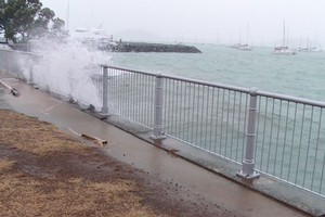
Video</figure>A rockfall also blocked part of the Hibiscus Coast Highway at Waiwera this morning.

Rainfall forecasts indicated that accumulations might be higher than previously modelled, Mr Richards said.

Rain north of Orewa could see an additional 50mm - 70mm today with lesser amounts for the rest of the region and waves were expected to surge at high tide this evening.

Winds were still expected to increase in strength and peak this afternoon and coastal erosion was still expected on northeastern beaches later today.

WeatherWatch.co.nz analyst Philip Duncan said the storm still retained category 1 strength winds with sustained gales near the centre and gusts over 100km/h.

The terrain of New Zealand was helping boost those wind speeds further in some exposed parts of Northland.
In Auckland winds were gale force in some places while other suburbs are fairly calm, he said.

"The former tropical storm is about 200kms north of Cape Reinga and will slowly drift past the Far North later this afternoon,'' Mr Duncan said.

Winds were expected to continue to increase across today across the North Island.

Overnight a number of trees came down on State Highway 14 between Whangarei and Dargaville, which have now been cleared, police said.
But debris is covering a number of roads and police were urging drivers in the north, to drive with care and to the conditions.
<figure class="inlineMedia inlineMedia-inline-video inlineMedia-right inlineMedia-width300" style="margin: 0px 0px 12px 16px; padding: 0px; border: 0px; outline: rgb(0, 0, 0); vertical-align: baseline; background-color: transparent; -webkit-transition: color 0.2s, background-color, border-color, opacity; transition: color 0.2s, background-color, border-color, opacity; clear: both; float: right; position: relative; width: 300px; max-width: 620px;"> 
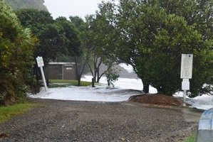
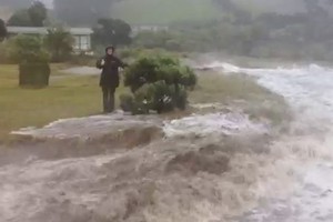
Video</figure>The fire service was also called to a felled tree on the Hibiscus Coast, about 5.30am, northern fire communications shift manager Nicole Bernard said.

Severe weather warnings have been issued for Northland, Auckland, Coromandel Peninsula, Bay of Plenty, Gisborne, Nelson and Marlborough.

Northland could expect 80mm-100mm of rain by this afternoon, MetService said.

The rain should spread quickly southwards, totalling more than 100mm in Coromandel, Bay of Plenty and Gisborne by Sunday morning.

Housing New Zealand also said it would make extra staff available over the weekend, with maintenance contractors ready to deal with any urgent repairs.

However, residents in at-risk coastal areas have been told it's a case of "neighbour helping neighbour'' to ensure safety. A number of Auckland's eastern and north-east beaches have been warned of potential erosion and damage to beachfront properties from high sea swells, particularly around high tide.

Boaties have been advised to secure their boats ahead of the encroaching storm, and avoid going out to sea over the weekend.

The brunt of Cyclone Lusi's force was expected to strike the North Island throughout today, before gradually weakening as it moves into the South Island tomorrow.
The storm should be clear of New Zealand by Monday, with only a few showers and brisk winds remaining in the south and east.

Canterbury was bracing itself for more flooding, with the Christchurch City Council saying it was preparing for the worst case scenario following recent damaging floods in the area.

About 22,000 sandbags will be filled and ready for collection in various locations across the city by noon today, with all emergency response teams on stand-by.
Meanwhile, farmers are welcoming the expected onslaught of rain for their parched land, particularly the west coast of the North Island, Waikato, Auckland and Hauraki Coromandel.

"I know there'll be a fair number of farmers in Waikato and Northland who'll dance a jig at the first drops of rain,'' said Katie Milne, Federated Farmers adverse events spokeswoman.

"Some on the North Island's west coast haven't seen decent rain since last November.''

However, she warned farmers to be prepared for the storm conditions in advance

 
Top