
- Joined
- Feb 20, 2010
- Messages
- 2,818
- Points
- 48
https://sports.sina.cn/outdoor/2020-05-27/detail-iirczymk3782208.d.html?vt=4&pos=108&his=0
见证历史!珠峰高程测量登山队冲顶成功
 新京报
新京报
05月27日 11:04关注
新京报快讯(记者 吴娇颖)刚刚,2020珠峰高程测量登山队登顶珠峰。5月27日凌晨2点10分,测量登山队8名队员从海拔8300米的突击营地出发,冲顶珠峰。
按照计划,测量登山队员将在峰顶竖起测量觇标,开展全球导航卫星系统测量和雪深测量等工作。位于大本营、中绒布冰川、西绒布冰川等6个交会点的测量登山队员将瞄准峰顶觇标,同步开展测量。
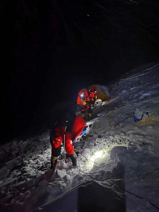
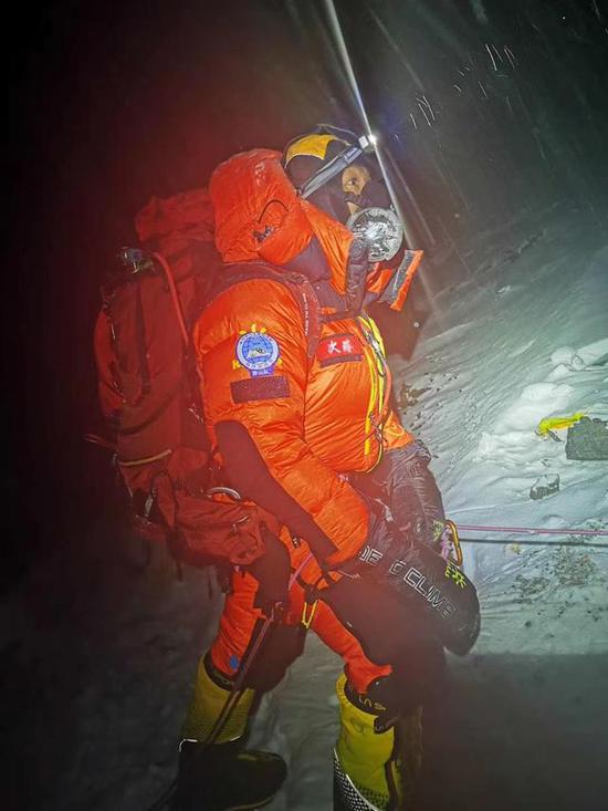
2020珠峰高程测量登山队5月27日2点10分出发,冲顶珠峰。扎西次仁 摄
测量登山队三次向珠峰峰顶发起冲击
2020珠峰测量路线包括六个营地,直线距离约19公里,高差约3600米。测量登山队员需从海拔5200米的珠峰大本营出发,途经中绒布冰川和东绒布冰川抵达海拔5800米的中间营地宿营,再前往海拔6500米的前进营地,此处氧气非常稀少,高原反应强烈。
休整完毕后,队员们需途经海拔6600米至7000米的北坳大冰壁,再途经海拔7028米的一号营地、海拔7500米的大风口、海拔7790米的二号营地,到达海拔8300米的三号营地,最后的冲击需经过海拔8680米至8700米的第二台阶。
此前,5月6日,2020珠峰高程测量登山队第一次向珠峰顶峰进发。5月8日,修路队员准备通过北坳冰壁时,发现攀登路线上雪比较深,有流雪的危险,撤回前进营地。登顶时间比原定日期延后。因天气原因,队员分两批撤回大本营进行休整,等待第二个冲顶窗口期。
2020珠峰高程测量登山队5月27日2点10分出发,冲顶珠峰。扎西次仁 摄
5月16日,测量登山队再次冲顶,预计5月22日为攻顶日。但因天气原因,海拔7790米以上区域,雪深过米,为保障队员安全,测量登山队决定撤回6500米前进营地,休整待命。
5月24日,测量登山队第三次向顶峰发起突击。5月26日,次落、袁复栋、李富庆、普布顿珠、次仁多吉、次仁平措、次仁罗布、洛桑顿珠8名队员从海拔7790米的C2营地出发,抵达海拔8300米的突击营地。26日下午,经过12个半小时的奋战,测量登山队冲锋修路组6名队员把安全路线绳全程铺设至珠峰峰顶。
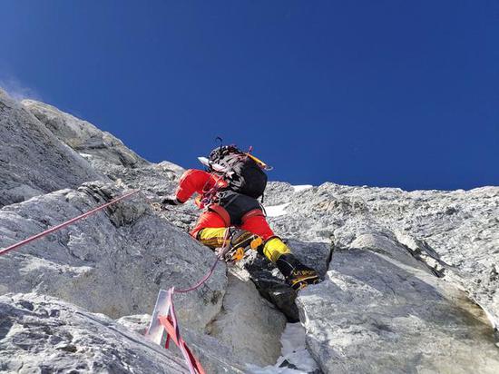
5月26日下午,修路队员通过第一台阶。旦增罗布 摄
测量成果将为冰川变化、地壳运动等研究提供第一手资料
2020珠峰高程测量于4月30日正式启动,由自然资源部会同外交部、国家体育总局和西藏自治区政府组织。这是继2005年公布8844.43米的珠峰峰顶岩石面海拔高程后,我国时隔15年再测世界最高峰。
珠峰高程测量的核心是精确测定珠穆朗玛峰高度,这同时也是一项代表国家测绘科技发展水平的综合性测绘工程。据悉,本次珠峰高程测量依托北斗卫星导航系统开展,应用航空重力技术提升测量精度,并利用实景三维技术直观展示珠峰自然资源状况。
此前,珠峰高程测量已经做了大量的前期准备工作。国测一大队53名测绘队员,自3月2日起,在珠峰及外围地区陆续开展了水准、重力、卫星定位、天文等测量工作,完成了6个珠峰高程测量交会点的踏勘、选埋、高程传递等基础性测量工作。
中国测绘科学研究院副研究员、2020珠峰高程测量技术协调组专家成员蒋涛告诉记者,登顶测量只是完成了最重要的测量数据,但真正的结果——珠峰的高度,还需要经过一段时间的数据处理和反复检核计算。
据介绍,此次珠峰高程测量的成果可用于地球动力学板块运动等领域研究。精确的峰顶雪深、气象和风速等数据,将为冰川监测、生态环境保护等方面的研究提供第一手资料。重力测量成果可用于珠峰地区区域地球重力场模型的建立和冰川变化、地震、地壳运动等问题的研究。
新京报记者 吴娇颖
Witness history! Mount Everest's height measurement team climbed to the top successfully

Beijing News
May 27th 11:04 Follow
Beijing News (Reporter Wu Jiaoying) Just now, the Mount Everest 2020 mountaineering team summited Mount Everest. At 2:10 a.m. on May 27, eight members of the mountaineering team set off from the assault camp at an altitude of 8300 meters and reached the summit of Mount Everest.
According to the plan, the surveying mountaineering team will set up a survey target on the peak, and carry out the work of global navigation satellite system survey and snow depth survey. The mountaineers at the 6 intersections of Base Camp, Zhongrongbu Glacier, and West Rongbu Glacier will aim at the peak target and carry out the survey simultaneously.

The Mount Everest 2020 mountaineering team set off at 2:10 on May 27 to reach the summit of Mount Everest. Photo by Tashi Tsering
Measure the mountaineering team to launch an impact on the summit of Mount Everest three times
The 2020 Everest survey route includes six camps with a straight-line distance of about 19 kilometers and a height difference of about 3600 meters. Surveying mountaineers must start from Mount Everest Base Camp at an altitude of 5200 meters, pass through the middle Rongbuk Glacier and the East Rongbuk Glacier to reach an intermediate camp camping at an altitude of 5800 meters, and then go to a forward camp at an altitude of 6500 meters. Here, oxygen is very scarce and the plateau reaction is strong.
After the rest, the team members need to pass through the Bei'ao Great Ice Wall at an altitude of 6600 meters to 7000 meters, and then pass through Camp No. 1 at an altitude of 7028 meters, Dafengkou at an altitude of 7500 meters, and Camp No. 2 at an altitude of 7790 meters to reach an altitude of 8300 meters. In Camp No. 3, the final impact must pass through the second step from 8680 meters to 8700 meters above sea level.
Earlier, on May 6, the Mount Everest 2020 mountaineering team made its first foray to the summit of Mount Everest. On May 8th, when the road construction team was about to pass through the Bei'ao ice wall, they found that the climbing route had deep snow and there was a danger of drifting snow, and they withdrew to the forward camp. The summit time is later than the original date. Due to the weather, the team members withdrew from the base camp in two batches for rest, waiting for the second peak window period.

The Mount Everest 2020 mountaineering team set off at 2:10 on May 27 to reach the summit of Mount Everest. Photo by Tashi Tsering
On May 16, the measurement mountaineering team made another summit, and May 22 is expected to be the top day. However, due to weather conditions, the area above the altitude of 7790 meters and the snow depth exceeded the meter. In order to ensure the safety of the team members, the mountaineering team decided to withdraw to the 6,500-meter forward camp and rest on standby.
On May 24, the surveying mountaineering team launched a surprise attack on the summit for the third time. On May 26th, 8 members of Ciluo, Yuan Fudong, Li Fuqing, Pu Budunzhu, Ciren Doji, Ciren Pingcuo, Ciren Rob, and Lausanne Dunzhu departed from the C2 camp at an altitude of 7790 meters and arrived at an assault of 8300 meters Camp. On the afternoon of the 26th, after 12 and a half hours of hard work, the six members of the mountaineering team's charge road repair team laid the safety route to the summit of Mount Everest.

On the afternoon of May 26, the road construction team passed the first step. Photo by Tenzin Robb
The measurement results will provide first-hand information for the study of glacier changes and crustal movement
The 2020 Mount Everest elevation measurement was officially launched on April 30, organized by the Ministry of Natural Resources in conjunction with the Ministry of Foreign Affairs, the State Sports General Administration and the Tibet Autonomous Region Government. This is the highest peak in the world after 15 years since China announced the elevation of the rock surface elevation of the Mount Everest at 8844.43 meters in 2005.
The core of Everest elevation measurement is the accurate determination of the height of Mount Everest, which is also a comprehensive surveying and mapping project representing the development level of national surveying and mapping technology. It is reported that the height measurement of Mount Everest relies on the Beidou satellite navigation system, the application of aviation gravity technology to improve the measurement accuracy, and the use of real three-dimensional technology to visually display the natural resources of Mount Everest.
Prior to this, the Everest elevation measurement has done a lot of preparatory work. The 53 surveying and mapping members of the first national survey team have carried out leveling, gravity, satellite positioning, astronomy and other surveying work in the Everest and surrounding areas since March 2, and completed the survey and survey of the six Everest elevation measurement intersections. Basic measurement work such as burying and elevation transmission.
Jiang Tao, an associate researcher of the Chinese Academy of Surveying and Mapping and an expert member of the 2020 Everest Height Measurement Technology Coordination Group, told reporters that the summit measurement only completed the most important measurement data, but the real result-the height of Mount Everest still needs a period of time. Time data processing and repeated check calculations.
According to reports, the results of the Everest elevation measurement can be used in the field of geodynamic plate motion research. Accurate data such as peak snow depth, weather and wind speed will provide first-hand information for studies on glacier monitoring and ecological environmental protection. Gravity measurement results can be used for the establishment of the regional earth gravity field model in the Everest region and the study of glacial changes, earthquakes, crustal movement and other issues.
Beijing News reporter Wu Jiaoying
见证历史!珠峰高程测量登山队冲顶成功
05月27日 11:04关注
新京报快讯(记者 吴娇颖)刚刚,2020珠峰高程测量登山队登顶珠峰。5月27日凌晨2点10分,测量登山队8名队员从海拔8300米的突击营地出发,冲顶珠峰。
按照计划,测量登山队员将在峰顶竖起测量觇标,开展全球导航卫星系统测量和雪深测量等工作。位于大本营、中绒布冰川、西绒布冰川等6个交会点的测量登山队员将瞄准峰顶觇标,同步开展测量。
2020珠峰高程测量登山队5月27日2点10分出发,冲顶珠峰。扎西次仁 摄
测量登山队三次向珠峰峰顶发起冲击
2020珠峰测量路线包括六个营地,直线距离约19公里,高差约3600米。测量登山队员需从海拔5200米的珠峰大本营出发,途经中绒布冰川和东绒布冰川抵达海拔5800米的中间营地宿营,再前往海拔6500米的前进营地,此处氧气非常稀少,高原反应强烈。
休整完毕后,队员们需途经海拔6600米至7000米的北坳大冰壁,再途经海拔7028米的一号营地、海拔7500米的大风口、海拔7790米的二号营地,到达海拔8300米的三号营地,最后的冲击需经过海拔8680米至8700米的第二台阶。
此前,5月6日,2020珠峰高程测量登山队第一次向珠峰顶峰进发。5月8日,修路队员准备通过北坳冰壁时,发现攀登路线上雪比较深,有流雪的危险,撤回前进营地。登顶时间比原定日期延后。因天气原因,队员分两批撤回大本营进行休整,等待第二个冲顶窗口期。
2020珠峰高程测量登山队5月27日2点10分出发,冲顶珠峰。扎西次仁 摄
5月16日,测量登山队再次冲顶,预计5月22日为攻顶日。但因天气原因,海拔7790米以上区域,雪深过米,为保障队员安全,测量登山队决定撤回6500米前进营地,休整待命。
5月24日,测量登山队第三次向顶峰发起突击。5月26日,次落、袁复栋、李富庆、普布顿珠、次仁多吉、次仁平措、次仁罗布、洛桑顿珠8名队员从海拔7790米的C2营地出发,抵达海拔8300米的突击营地。26日下午,经过12个半小时的奋战,测量登山队冲锋修路组6名队员把安全路线绳全程铺设至珠峰峰顶。
5月26日下午,修路队员通过第一台阶。旦增罗布 摄
测量成果将为冰川变化、地壳运动等研究提供第一手资料
2020珠峰高程测量于4月30日正式启动,由自然资源部会同外交部、国家体育总局和西藏自治区政府组织。这是继2005年公布8844.43米的珠峰峰顶岩石面海拔高程后,我国时隔15年再测世界最高峰。
珠峰高程测量的核心是精确测定珠穆朗玛峰高度,这同时也是一项代表国家测绘科技发展水平的综合性测绘工程。据悉,本次珠峰高程测量依托北斗卫星导航系统开展,应用航空重力技术提升测量精度,并利用实景三维技术直观展示珠峰自然资源状况。
此前,珠峰高程测量已经做了大量的前期准备工作。国测一大队53名测绘队员,自3月2日起,在珠峰及外围地区陆续开展了水准、重力、卫星定位、天文等测量工作,完成了6个珠峰高程测量交会点的踏勘、选埋、高程传递等基础性测量工作。
中国测绘科学研究院副研究员、2020珠峰高程测量技术协调组专家成员蒋涛告诉记者,登顶测量只是完成了最重要的测量数据,但真正的结果——珠峰的高度,还需要经过一段时间的数据处理和反复检核计算。
据介绍,此次珠峰高程测量的成果可用于地球动力学板块运动等领域研究。精确的峰顶雪深、气象和风速等数据,将为冰川监测、生态环境保护等方面的研究提供第一手资料。重力测量成果可用于珠峰地区区域地球重力场模型的建立和冰川变化、地震、地壳运动等问题的研究。
新京报记者 吴娇颖
Witness history! Mount Everest's height measurement team climbed to the top successfully

Beijing News
May 27th 11:04 Follow
Beijing News (Reporter Wu Jiaoying) Just now, the Mount Everest 2020 mountaineering team summited Mount Everest. At 2:10 a.m. on May 27, eight members of the mountaineering team set off from the assault camp at an altitude of 8300 meters and reached the summit of Mount Everest.
According to the plan, the surveying mountaineering team will set up a survey target on the peak, and carry out the work of global navigation satellite system survey and snow depth survey. The mountaineers at the 6 intersections of Base Camp, Zhongrongbu Glacier, and West Rongbu Glacier will aim at the peak target and carry out the survey simultaneously.

The Mount Everest 2020 mountaineering team set off at 2:10 on May 27 to reach the summit of Mount Everest. Photo by Tashi Tsering
Measure the mountaineering team to launch an impact on the summit of Mount Everest three times
The 2020 Everest survey route includes six camps with a straight-line distance of about 19 kilometers and a height difference of about 3600 meters. Surveying mountaineers must start from Mount Everest Base Camp at an altitude of 5200 meters, pass through the middle Rongbuk Glacier and the East Rongbuk Glacier to reach an intermediate camp camping at an altitude of 5800 meters, and then go to a forward camp at an altitude of 6500 meters. Here, oxygen is very scarce and the plateau reaction is strong.
After the rest, the team members need to pass through the Bei'ao Great Ice Wall at an altitude of 6600 meters to 7000 meters, and then pass through Camp No. 1 at an altitude of 7028 meters, Dafengkou at an altitude of 7500 meters, and Camp No. 2 at an altitude of 7790 meters to reach an altitude of 8300 meters. In Camp No. 3, the final impact must pass through the second step from 8680 meters to 8700 meters above sea level.
Earlier, on May 6, the Mount Everest 2020 mountaineering team made its first foray to the summit of Mount Everest. On May 8th, when the road construction team was about to pass through the Bei'ao ice wall, they found that the climbing route had deep snow and there was a danger of drifting snow, and they withdrew to the forward camp. The summit time is later than the original date. Due to the weather, the team members withdrew from the base camp in two batches for rest, waiting for the second peak window period.

The Mount Everest 2020 mountaineering team set off at 2:10 on May 27 to reach the summit of Mount Everest. Photo by Tashi Tsering
On May 16, the measurement mountaineering team made another summit, and May 22 is expected to be the top day. However, due to weather conditions, the area above the altitude of 7790 meters and the snow depth exceeded the meter. In order to ensure the safety of the team members, the mountaineering team decided to withdraw to the 6,500-meter forward camp and rest on standby.
On May 24, the surveying mountaineering team launched a surprise attack on the summit for the third time. On May 26th, 8 members of Ciluo, Yuan Fudong, Li Fuqing, Pu Budunzhu, Ciren Doji, Ciren Pingcuo, Ciren Rob, and Lausanne Dunzhu departed from the C2 camp at an altitude of 7790 meters and arrived at an assault of 8300 meters Camp. On the afternoon of the 26th, after 12 and a half hours of hard work, the six members of the mountaineering team's charge road repair team laid the safety route to the summit of Mount Everest.

On the afternoon of May 26, the road construction team passed the first step. Photo by Tenzin Robb
The measurement results will provide first-hand information for the study of glacier changes and crustal movement
The 2020 Mount Everest elevation measurement was officially launched on April 30, organized by the Ministry of Natural Resources in conjunction with the Ministry of Foreign Affairs, the State Sports General Administration and the Tibet Autonomous Region Government. This is the highest peak in the world after 15 years since China announced the elevation of the rock surface elevation of the Mount Everest at 8844.43 meters in 2005.
The core of Everest elevation measurement is the accurate determination of the height of Mount Everest, which is also a comprehensive surveying and mapping project representing the development level of national surveying and mapping technology. It is reported that the height measurement of Mount Everest relies on the Beidou satellite navigation system, the application of aviation gravity technology to improve the measurement accuracy, and the use of real three-dimensional technology to visually display the natural resources of Mount Everest.
Prior to this, the Everest elevation measurement has done a lot of preparatory work. The 53 surveying and mapping members of the first national survey team have carried out leveling, gravity, satellite positioning, astronomy and other surveying work in the Everest and surrounding areas since March 2, and completed the survey and survey of the six Everest elevation measurement intersections. Basic measurement work such as burying and elevation transmission.
Jiang Tao, an associate researcher of the Chinese Academy of Surveying and Mapping and an expert member of the 2020 Everest Height Measurement Technology Coordination Group, told reporters that the summit measurement only completed the most important measurement data, but the real result-the height of Mount Everest still needs a period of time. Time data processing and repeated check calculations.
According to reports, the results of the Everest elevation measurement can be used in the field of geodynamic plate motion research. Accurate data such as peak snow depth, weather and wind speed will provide first-hand information for studies on glacier monitoring and ecological environmental protection. Gravity measurement results can be used for the establishment of the regional earth gravity field model in the Everest region and the study of glacial changes, earthquakes, crustal movement and other issues.
Beijing News reporter Wu Jiaoying
