
Lai Liao Twin Eye Super-Typhoon Lekima!

https://weather.com/storms/hurricane/news/2019-08-07-typhoon-lekima-forecast-taiwan-china-japan
Hurricane Central
Super Typhoon Lekima Hammering Japan's Ryukyu Islands and Soaking Taiwan Before Heading to Eastern China
By weather.com meteorologists
3 hours ago
weather.com
01:10
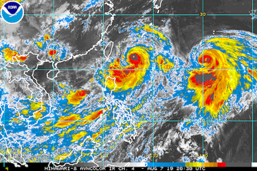
Twin Typhoons in the Western Pacific
Meteorologist Domenica Davis looks at the forecast for Super Typhoon Lekima and Typhoon Krosa.
At a Glance
Lekima is currently centered more than 240 miles southwest of Kadena Air Base in Okinawa and is heading northwestward.
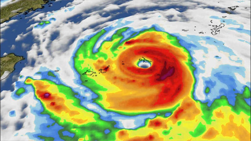
After rapidly intensifying Tuesday into Wednesday, Lekima has continued to strengthen and is now a super typhoon (winds 150 mph or greater). That makes Lekima equivalent in strength to a strong Category 4 hurricane.
Damaging winds and heavy rain are already battering Japan's southernmost Ryukyu Islands, including Ishigaki and Miyako. Winds had gusted as high as 72 mph at Miyakojima airport as of late Thursday afternoon local time.
Japan's Meteorological Agency has issued storm warnings, equivalent to typhoon warnings, for the southern Ryukyu Islands. Storm surge warnings have also been issued.

<img class="styles__noscript__2rw2y" src="https://s.w-x.co/staticmaps/DCT_SPECIAL13_1280x720.jpg" srcset="https://s.w-x.co/staticmaps/DCT_SPECIAL13_1280x720.jpg 400w, https://s.w-x.co/staticmaps/DCT_SPECIAL13_1280x720.jpg 800w" >
Projected Path
(The red-shaded area denotes the potential path of the center of the tropical cyclone. It's important to note that impacts (particularly heavy rain, high surf, coastal flooding, winds) with any tropical cyclone usually spread beyond its forecast path. Local time in Taiwan is shown. Add one hour for Japanese time.)
Lekima is forecast to move north of Taiwan on Friday, local time in Taiwan. Heavy rain and strong wind gusts from Lekima will still impact parts of Taiwan even though the center of the typhoon won't make landfall there.
The Central Weather Bureau in Taiwan has issued typhoon warnings for northern parts of Taiwan.
More than a foot of rain is currently forecast through Saturday in the higher elevations of Taiwan. The excessive rainfall could trigger flooding, as well as landslides.
Rainfall totals of more than 4 inches had already been reported on Thursday in parts of Taiwan as of 6 p.m. local time.
This weekend, Lekima will be on a weakening trend as it curls northward near the eastern coast of China, potentially including near Shanghai.
Heavy rain could trigger flooding in eastern China. Strong winds and storm surge flooding are also possible depending on the exact track and intensity of Lekima as it moves near, inland or offshore from the coastline.

Rainfall Forecast
(Locally higher amounts are possible.)
Typhoon Krosa
Several hundred miles to the east of Lekima is Typhoon Krosa which now has winds equivalent in strength to a Category 3 hurricane.
Krosa is forecast to drift near Iwo Jima and the Ogasawara Islands later this week but will otherwise remain over the open waters of the Western Pacific the next five days. Extended periods of gusty winds and heavy rainfall are expected in the Ogasawara Islands.
It's possible Krosa could approach mainland Japan early next week, but the forecast this far out in time is highly uncertain. Typhoon Lekima may have its hand in the direction of where Krosa goes as the two systems may get close enough to one another to cause some sort of interaction.
<img class="styles__noscript__2rw2y" src="https://s.w-x.co/staticmaps/DCT_SPECIAL15_1280x720.jpg" srcset="https://s.w-x.co/staticmaps/DCT_SPECIAL15_1280x720.jpg 400w, https://s.w-x.co/staticmaps/DCT_SPECIAL15_1280x720.jpg 800w" >
Projected Path
(The red-shaded area denotes the potential path of the center of the tropical cyclone. It's important to note that impacts (particularly heavy rain, high surf, coastal flooding, winds) with any tropical cyclone usually spread beyond its forecast path. Local time in Japan is shown.)
Recap: Francisco Strikes Japan as a Typhoon
Francisco made landfall in southern Japan as typhoon Tuesday morning local time, with maximum sustained winds of 85 mph, according to the U.S. Joint Typhoon Warning Center.
More than 15 inches of rain soaked the Tokushima Prefecture, according to the Japan Meteorological Agency. Parts of the Miyazaki Prefecture saw more than 10 inches of rain.
A Quiet Typhoon Season Before This Week
This year had been uncommonly calm for typhoon activity through Aug. 4 in the Northwest Pacific, which is normally the most active region on Earth for tropical cyclones. The only typhoon recorded in 2019 through Aug. 4 was Wutip, the first Category 5 super typhoon on record in February. Wutip passed south of Guam and Micronesia as a Category 4 storm, producing more than $3 million in damage.
Japan is accustomed to typhoons. In a typical year, three typhoons strike Japan, according to data from the Japan Meteorological Agency analyzed by nippon.com. Landfalls are most common in August, but the most destructive typhoons tend to be in September.
Since 1950, no other year had gone from Feb. 28 to Aug. 4 without any typhoons, as noted by Dr. Phil Klotzbach of Colorado State University. Francisco put an end to that streak when it became a typhoon on Aug. 5.
In a typical season (1981-2010), the Northwest Pacific sees about eight named storms and five typhoons by Aug. 2. This year had brought just five named storms and one typhoon by that date.
The amount of accumulated cyclone energy in the Northwest Pacific – which is calculated based on how strong tropical cyclones get and how long they last – was only a little over half of average for the year as of Aug. 2, according to data compiled by Colorado State University.
So, what's the difference between this quiet period and now?
At least one factor that may be having its hand on the "on" switch for the west Pacific is the Madden-Julian Oscillation.
The MJO is essentially a wave of increased storminess, clouds and pressure that moves eastward around the globe once every 40 days or so.
In the tropics, the MJO is known to kick up or assist in tropical cyclone development.
A robust MJO wave is now moving through eastern Asia and the western Pacific, and likely helped the recent tropical cyclone outbreak fester.
The Weather Company’s primary journalistic mission is to report on breaking weather news, the environment and the importance of science to our lives. This story does not necessarily represent the position of our parent company, IBM.
https://weather.com/storms/hurricane/news/2019-08-07-typhoon-lekima-forecast-taiwan-china-japan
Hurricane Central
Super Typhoon Lekima Hammering Japan's Ryukyu Islands and Soaking Taiwan Before Heading to Eastern China
By weather.com meteorologists
3 hours ago
weather.com
01:10
Twin Typhoons in the Western Pacific
Meteorologist Domenica Davis looks at the forecast for Super Typhoon Lekima and Typhoon Krosa.
At a Glance
- Lekima is currently pounding Japan's southern Ryukyu Islands and Taiwan.
- The typhoon will also threaten eastern China by this weekend.
- Lekima rapidly intensified from Tuesday into Wednesday and is now a super typhoon.
- Typhoon Krosa is also in the Western Pacific.
Lekima is currently centered more than 240 miles southwest of Kadena Air Base in Okinawa and is heading northwestward.
After rapidly intensifying Tuesday into Wednesday, Lekima has continued to strengthen and is now a super typhoon (winds 150 mph or greater). That makes Lekima equivalent in strength to a strong Category 4 hurricane.
Damaging winds and heavy rain are already battering Japan's southernmost Ryukyu Islands, including Ishigaki and Miyako. Winds had gusted as high as 72 mph at Miyakojima airport as of late Thursday afternoon local time.
Japan's Meteorological Agency has issued storm warnings, equivalent to typhoon warnings, for the southern Ryukyu Islands. Storm surge warnings have also been issued.
<img class="styles__noscript__2rw2y" src="https://s.w-x.co/staticmaps/DCT_SPECIAL13_1280x720.jpg" srcset="https://s.w-x.co/staticmaps/DCT_SPECIAL13_1280x720.jpg 400w, https://s.w-x.co/staticmaps/DCT_SPECIAL13_1280x720.jpg 800w" >
Projected Path
(The red-shaded area denotes the potential path of the center of the tropical cyclone. It's important to note that impacts (particularly heavy rain, high surf, coastal flooding, winds) with any tropical cyclone usually spread beyond its forecast path. Local time in Taiwan is shown. Add one hour for Japanese time.)
Lekima is forecast to move north of Taiwan on Friday, local time in Taiwan. Heavy rain and strong wind gusts from Lekima will still impact parts of Taiwan even though the center of the typhoon won't make landfall there.
The Central Weather Bureau in Taiwan has issued typhoon warnings for northern parts of Taiwan.
More than a foot of rain is currently forecast through Saturday in the higher elevations of Taiwan. The excessive rainfall could trigger flooding, as well as landslides.
Rainfall totals of more than 4 inches had already been reported on Thursday in parts of Taiwan as of 6 p.m. local time.
This weekend, Lekima will be on a weakening trend as it curls northward near the eastern coast of China, potentially including near Shanghai.
Heavy rain could trigger flooding in eastern China. Strong winds and storm surge flooding are also possible depending on the exact track and intensity of Lekima as it moves near, inland or offshore from the coastline.
Rainfall Forecast
(Locally higher amounts are possible.)
Typhoon Krosa
Several hundred miles to the east of Lekima is Typhoon Krosa which now has winds equivalent in strength to a Category 3 hurricane.
Krosa is forecast to drift near Iwo Jima and the Ogasawara Islands later this week but will otherwise remain over the open waters of the Western Pacific the next five days. Extended periods of gusty winds and heavy rainfall are expected in the Ogasawara Islands.
It's possible Krosa could approach mainland Japan early next week, but the forecast this far out in time is highly uncertain. Typhoon Lekima may have its hand in the direction of where Krosa goes as the two systems may get close enough to one another to cause some sort of interaction.
<img class="styles__noscript__2rw2y" src="https://s.w-x.co/staticmaps/DCT_SPECIAL15_1280x720.jpg" srcset="https://s.w-x.co/staticmaps/DCT_SPECIAL15_1280x720.jpg 400w, https://s.w-x.co/staticmaps/DCT_SPECIAL15_1280x720.jpg 800w" >
Projected Path
(The red-shaded area denotes the potential path of the center of the tropical cyclone. It's important to note that impacts (particularly heavy rain, high surf, coastal flooding, winds) with any tropical cyclone usually spread beyond its forecast path. Local time in Japan is shown.)
Recap: Francisco Strikes Japan as a Typhoon
Francisco made landfall in southern Japan as typhoon Tuesday morning local time, with maximum sustained winds of 85 mph, according to the U.S. Joint Typhoon Warning Center.
More than 15 inches of rain soaked the Tokushima Prefecture, according to the Japan Meteorological Agency. Parts of the Miyazaki Prefecture saw more than 10 inches of rain.
A Quiet Typhoon Season Before This Week
This year had been uncommonly calm for typhoon activity through Aug. 4 in the Northwest Pacific, which is normally the most active region on Earth for tropical cyclones. The only typhoon recorded in 2019 through Aug. 4 was Wutip, the first Category 5 super typhoon on record in February. Wutip passed south of Guam and Micronesia as a Category 4 storm, producing more than $3 million in damage.
Japan is accustomed to typhoons. In a typical year, three typhoons strike Japan, according to data from the Japan Meteorological Agency analyzed by nippon.com. Landfalls are most common in August, but the most destructive typhoons tend to be in September.
Since 1950, no other year had gone from Feb. 28 to Aug. 4 without any typhoons, as noted by Dr. Phil Klotzbach of Colorado State University. Francisco put an end to that streak when it became a typhoon on Aug. 5.
In a typical season (1981-2010), the Northwest Pacific sees about eight named storms and five typhoons by Aug. 2. This year had brought just five named storms and one typhoon by that date.
The amount of accumulated cyclone energy in the Northwest Pacific – which is calculated based on how strong tropical cyclones get and how long they last – was only a little over half of average for the year as of Aug. 2, according to data compiled by Colorado State University.
So, what's the difference between this quiet period and now?
At least one factor that may be having its hand on the "on" switch for the west Pacific is the Madden-Julian Oscillation.
The MJO is essentially a wave of increased storminess, clouds and pressure that moves eastward around the globe once every 40 days or so.
In the tropics, the MJO is known to kick up or assist in tropical cyclone development.
A robust MJO wave is now moving through eastern Asia and the western Pacific, and likely helped the recent tropical cyclone outbreak fester.
The Weather Company’s primary journalistic mission is to report on breaking weather news, the environment and the importance of science to our lives. This story does not necessarily represent the position of our parent company, IBM.