
- Joined
- Aug 8, 2008
- Messages
- 6,070
- Points
- 83
https://mil.news.sina.com.cn/2019-07-20/doc-ihytcitm3396146.shtml
让台风飓风海啸无处遁形 中国打造全球海洋观测网
2019年07月20日 16:30 新华网
14
7月18日,中央气象台继续发布台风蓝色预警,预报了今年第5号台风“丹娜丝”的行进时间、路径和其分裂出来的南海热带低压可能对东南部海域造成的影响。很多人听到该预警信息长舒了一口气,因为之前的预报信息显示,“丹娜丝”可能“分裂”成两个台风,形成双台风“共舞”的骇人破坏力;而18日的预报表明,其分裂出的南海热带低压未来强度变化不大。
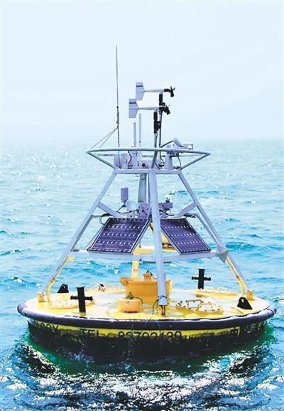 海上观测浮标站。新华社发
见微知著,对台风作出预测并发出预警信息,在很大程度上要依赖于我国已经建立的“国家全球海洋立体观测网”。该观测网是规模宏大的系统,包括国家海洋站网、海洋雷达站网、浮潜标网、海底观测网、表层漂流浮标网、剖面漂流浮标网等。通过这些网络,可以时时获取海温、海流、海浪等海洋环境要素信息,在此基础上进行综合分析研判,及时发出台风、飓风、风暴潮以及海啸等灾害侵袭预警,服务渔业捕捞、远洋运输、海上石油开采等生产活动。
卫星观海 一览无余
近日,国家全球海洋立体观测网迎来了两名“星”成员,它们是海洋一号C卫星和海洋二号B卫星。2018年9月和10月间,它们相继发射升空,之后完成了在轨测试并正式交付用户投入业务化应用。作为全球海洋立体观测网的重要组成部分,卫星海洋观(监)测系统以海洋卫星为主,兼顾其他卫星数据应用,服务于海洋观(监)测业务化系统,主要由系列海洋卫星(含载荷)、卫星地面应用系统、海上定标和真实性检验场等组成。
海洋卫星通过搭载各类遥感器来探测海洋环境信息,能够对全球海洋大范围、长时期地观测,为人类深入了解和认识海洋提供了其他观测方式都无法替代的数据源。经过多年不懈努力,中国已经初步形成了“海洋一号”“海洋二号”“高分三号”系列卫星为代表的海洋水色、海洋动力环境及海洋监视监测系列卫星,建立起了优势互补的海洋遥感卫星观测体系。
根据《海洋卫星业务发展“十三五”规划》,到2020年,中国将研制和发射十余颗海洋卫星,可为海洋环境资源、海洋防灾减灾、海洋经济、海洋生态、海洋安全等领域提供不同分辨率、不同时效、不同种类的丰富的多源海洋环境信息,广泛服务于气象、环境、交通、农业和水利等。
挺进极地 观测冷源
2019年,中国自主建造的第一艘极地科学考察破冰船——“雪龙2”号顺利交付,这无疑是世界极地科考领域最重大的事件之一。它的交付意味着中国形成了“雪龙”号和“雪龙2”号协同开展极地探测的“双龙探极”新格局,提升了中国极地科学考察现场保障和支撑能力。对中国全球海洋立体观测网建设而言,“双龙探极”新格局无疑把对极地海域的观测能力提升到新水平。
南北极作为地球的两大冷源,左右着全球冷暖过程,在包括两极海域在内的极地地区形成立体观测能力对于掌握全球气候变化,分析重大气象过程的产生和发展机理等具有重大意义。中国一直致力于极地进入、极地科考能力建设。
在南极科考方面,从1984年派出首支南极科考队开始,中国先后建成了长城站、中山站、昆仑站和泰山站,第五座科考站选址南极罗斯海地区并进入建设阶段。截止目前,中国已经实施了35次南极科考。北极科考方面,2004年7月,北极黄河站在挪威斯匹次卑尔根群岛的新奥尔松地区建立。截至目前,中国已经实施了9次北极科考。海洋观测是中国极地科考的核心内容之一,中国在极地已经形成了站基、海基、空基、冰基等构成的立体海洋观测网络。特别值得一提的是,在2018年中国第九次北极考察期间,中国科考队成功在冰区布放了两套海-冰-气无人冰站观测系统,首次实现对北极海洋、海冰和大气的全要素观测,将为研究北极海冰变化过程和机理、准确预测北极气候和海冰变化趋势等提供科学数据支撑。在2018年第34次南极考察期间,中国科考队在南极罗斯海特拉诺瓦湾开展地球物理调查,获取了海底地形、海洋重力、磁力数据。这是“雪龙”船首次以全覆盖勘测方式获取南极海洋的海底地形地貌资料。
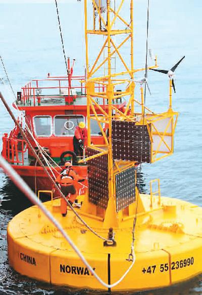
2012年8月4日,中国科考队员在挪威海域布放中国首个极地大型海洋观测浮标。新华社发
制度保障 整合力量
制度建设是海洋立体观测系统的建立和观测能力提升的重要保障。近年来,中国出台了一系列相关政策规范,其中包括《海洋观测预报管理条例》《全国海洋观测网规划(2014年~2020年)》《海洋气象发展规划(2016年~2025年)》,对加大海洋观测基础设施投入、提高观测仪器设备先进性、建设海洋观测体系、规范海洋观测管理、积极参与国际观测计划等起到显著的推动作用。
2016年,国家“十三五”规划纲要明确将“全球海洋立体观测网”列为重大工程,要求统筹规划国家海洋观(监)测网布局,推进国家海洋环境实时在线监控系统和海外观(监)测站点建设,逐步形成全球海洋立体观(监)测系统,加强对海洋生态、洋流、海洋气象等方面的观测研究。
经过多年发展,中国海洋观测已初步具备全球海洋立体观测雏形。目前已拥有包括海洋站(点)、雷达、海洋观测平台、浮标、移动应急观测、志愿船、标准海洋断面调查和卫星等多手段的海洋观测能力,近岸近海观测已初步覆盖管辖海域,极地和大洋热点海域观测有效开展,卫星遥感观测手段趋于成熟,海洋观测数据传输效率大幅提高,海洋立体观测体系更趋完善。
国家海洋技术中心是国家全球海洋立体观测网技术总体单位,该技术中心相关负责人介绍,“十三五”开局是中国海洋观测能力进一步提升的重要时间节点,此后,有关方面有效整合国家海洋观(监)测能力,建成布局合理、规模适当、体系完整的中国全球海洋立体观(监)测系统,形成覆盖中国管辖海域和大洋重点海域的业务化观(监)测能力,满足海洋经济发展、海洋防灾减灾、海洋生态预警、海洋资源开发利用和海上航行安全保障等多方面对海洋观(监)测的需求。
携手合作 互利共赢
作为支撑海洋事业发展的基础,海洋观测受到世界各国高度重视。联合国教科文组织政府间海洋学委员会、世界气象组织、国际科学联合会理事会和联合国环境规划署于1993年发起并组织实施了全球海洋观测系统(GOOS)计划,现已发展为13个区域性观测系统,针对不同要素包括全球海平面观测、全球海洋漂流浮标观测、全球Argo浮标观测、国际海洋碳观测等多个专题观测计划。
据国家海洋技术中心副研究员王祎介绍,在GOOS等全球性计划引领下,目前国际海洋观测已进入多平台、多传感器集成的立体观测时代,呈现出业务化观测系统与科学观测试验计划相结合、区域与全球相结合、“天-空-岸-海”多手段相结合、国际合作数据贡献与共享相结合的特征。全球海洋观测系统正在逐步建成,全球海洋观测能力稳步增强。
王祎说:“我国将深度参与国际观测计划,重点建设覆盖太平洋台风活跃区、厄尔尼诺变异等重点关注区的长期观(监)测系统,提升对大洋环流、台风生成和传播、厄尔尼诺/拉尼娜现象、珊瑚礁退化、海洋酸化等重要海洋、气候和环境变化过程的实时监测和预测能力。”
此外,中国将与参加“中国-小岛屿国家海洋部长圆桌会议”并与达成协议的小岛屿国家共同建设和维护岛礁生态联测系统;与“21世纪海上丝绸之路”沿线国家共同建设和维护海洋观(监)测系统,提升“海丝”沿线国家的海洋灾害预报观测能力,助力实现合作共赢。
Let the typhoon hurricane and tsunami have nowhere to shape China builds a global ocean observing network
July 20, 2019 16:30 Xinhua Net
14
On July 18th, the Central Meteorological Observatory continued to issue a typhoon blue warning, predicting the impact of the typhoon “Danas” on the 5th of this year, the path and the split tropical South China Sea depression on the southeastern sea. Many people have heard this warning message with a sigh of relief, because the previous forecast information shows that “Danas” may “split” into two typhoons, forming a destructive force for the double typhoon “to dance”; The forecast shows that the split strength of the South China Sea tropical low pressure does not change much.
Observing the buoy station at sea. Xinhua News Agency issued a sea observation buoy station. Xinhua News Agency
Seeing the micro-knowledge, making predictions about typhoons and issuing early warning information depends to a large extent on the “National Global Ocean Stereo Observing Network” that has been established in China. The observation network is a large-scale system, including the national marine station network, the marine radar station network, the snorkeling standard network, the seabed observation network, the surface drifting buoy network, and the profile drifting buoy network. Through these networks, information on marine environmental factors such as sea temperature, ocean currents, and ocean waves can be obtained from time to time. Based on this, comprehensive analysis and judgment will be conducted to timely issue typhoon, hurricane, storm surge, and tsunami and other disaster intrusion warnings, service fishery fishing, ocean transportation, Production activities such as offshore oil exploration.
Satellite view of the sea
Recently, the National Global Ocean Stereo Observing Network has ushered in two "Star" members, which are the Ocean One C satellite and the Ocean No. 2 B satellite. In September and October 2018, they were launched into the air, and then completed the on-orbit test and officially delivered the user into the operational application. As an important part of the global ocean stereoscopic observation network, the satellite ocean view (monitoring) measurement system is mainly based on marine satellites, taking into account other satellite data applications, serving the ocean view (monitoring) measurement business system, mainly by a series of marine satellites (including Load), satellite ground application system, maritime calibration and authenticity inspection field.
By using various types of remote sensors to detect marine environment information, ocean satellites can provide a wide range of long-term observations of the global ocean, providing a source of data that cannot be replaced by other means of observation for human understanding and understanding of the ocean. After years of unremitting efforts, China has initially formed a series of satellites of ocean water color, marine power environment and ocean surveillance and monitoring, represented by the series of "Ocean No. 1", "Ocean No. 2" and "High Score No. 3" satellites, and established complementary advantages. Marine Remote Sensing Satellite Observation System.
According to the "13th Five-Year Plan for the Development of Marine Satellite Business", by 2020, China will develop and launch more than ten marine satellites, which can be used in marine environmental resources, marine disaster prevention and mitigation, marine economy, marine ecology, and marine security. Provide a variety of multi-source marine environment information with different resolutions, different aging, and different types, widely used in meteorology, environment, transportation, agriculture and water conservancy.
Advance into the polar field
In 2019, China's first polar scientific research icebreaker, the "Snow Dragon 2", was successfully delivered, which is undoubtedly one of the most important events in the world's polar science research field. Its delivery means that China has formed a new pattern of “Shuanglong Exploration” that “Snow Dragon” and “Snowlong 2” cooperate to carry out polar exploration, which enhances the on-site support and support capability of China's polar scientific investigation. For the construction of China's global ocean stereoscopic observation network, the new pattern of “Shuanglong Exploration” will undoubtedly raise the observation capability of the polar seas to a new level.
As the two major cold sources of the Earth, the Arctic and the Arctic influence the global warm and cold process. The formation of stereoscopic observation capabilities in the polar regions including the polar seas is of great significance for mastering global climate change and analyzing the generation and development mechanism of major meteorological processes. China has always been committed to the establishment of polar and polar scientific research capabilities.
In the Antarctic expedition, from the first Antarctic expedition team sent in 1984, China has built the Great Wall Station, Zhongshan Station, Kunlun Station and Taishan Station. The fifth scientific research station is located in the Rossan area of the Antarctic and enters the construction stage. . Up to now, China has implemented 35 Antarctic expeditions. In the Arctic expedition, in July 2004, the Arctic Yellow River was established in the New Orleans area of Spitsbergen, Norway. So far, China has implemented nine Arctic exams. Ocean observation is one of the core contents of the Chinese Polar Science Examination. China has formed a three-dimensional ocean observation network consisting of station base, sea base, space base and ice base. It is particularly worth mentioning that during the ninth Arctic expedition in China in 2018, the Chinese expedition team successfully deployed two sets of sea-ice-air unmanned ice station observing systems in the ice zone, achieving the first for the Arctic ocean and sea. The full-element observation of ice and atmosphere will provide scientific data support for studying the process and mechanism of Arctic sea ice changes and accurately predicting the Arctic climate and sea ice trends. During the 34th Antarctic expedition in 2018, the Chinese expedition team conducted a geophysical survey in the Arctic Rossa Tranova Bay, acquiring seabed topography, ocean gravity, and magnetic data. This is the first time that the "Snow Dragon" ship has acquired the seabed topography and geomorphology data of the Antarctic Ocean by full coverage survey.
On August 4, 2012, Chinese expedition members deployed China's first polar large-scale ocean observation buoy in the Norwegian waters. Xinhua News Agency
Institutional guarantee
System construction is an important guarantee for the establishment of ocean stereoscopic observation systems and the improvement of observation capabilities. In recent years, China has issued a series of related policy norms, including the Regulations on the Management of Ocean Observation and Forecast, the National Ocean Observing Network (2014~2020), and the Marine Meteorological Development Plan (2016~2025). It has played a significant role in increasing the investment in marine observation infrastructure, improving the advanced nature of observation equipment, building a marine observation system, standardizing marine observation management, and actively participating in international observation programs.
In 2016, the National “13th Five-Year Plan” clearly listed the “Global Ocean Stereo Observing Network” as a major project, requiring the overall planning of the National Ocean View (Supervision) survey network layout, and promoting the national marine environment real-time online monitoring system and sea appearance ( Supervision) The construction of the site will gradually form a global ocean stereoscopic (supervisory) survey system, and strengthen observational research on marine ecology, ocean currents, and marine meteorology.
After years of development, China's ocean observations have initially possessed the prototype of global ocean stereoscopic observation. At present, it has ocean observation capabilities including marine stations (points), radars, ocean observation platforms, buoys, mobile emergency observations, volunteer ships, standard ocean section surveys and satellites. Nearshore and offshore observations have initially covered jurisdictional waters, polar regions. The observations of the ocean hotspots have been carried out effectively, the satellite remote sensing observation methods have matured, the ocean observation data transmission efficiency has been greatly improved, and the ocean stereoscopic observation system has become more perfect.
The National Ocean Technology Center is the overall unit of the National Global Ocean Stereo Observing Network. The relevant person in charge of the technology center introduced that the “13th Five-Year Plan” is an important time node for the further improvement of China's ocean observation capability. Since then, the relevant parties have effectively integrated the national ocean view. (Supervise) testing capability, build a China Global Ocean Stereoscopic (Supervisory) Survey System with reasonable layout, appropriate scale and complete system, and form a business-oriented (supervisory) testing capability covering China's jurisdiction and key ocean areas to meet the development of the marine economy. The demand for marine observation (monitoring) is measured in many aspects such as marine disaster prevention and mitigation, marine ecological early warning, development and utilization of marine resources, and safety of maritime navigation.
Work together for mutual benefit
As the basis for supporting the development of the marine industry, ocean observation has been highly valued by countries all over the world. The UNESCO Intergovernmental Oceanographic Commission, the World Meteorological Organization, the International Council of Scientific Unions and the United Nations Environment Programme initiated and organized the implementation of the Global Ocean Observing System (GOOS) programme in 1993, which has now evolved into 13 regional The observing system targets a number of thematic observations, including global sea level observations, global ocean drifting buoy observations, global Argo buoy observations, and international ocean carbon observations.
According to Wang Wei, an associate researcher at the National Ocean Technology Center, under the guidance of global programs such as GOOS, international ocean observation has entered the multi-platform, multi-sensor integrated stereoscopic observation era, presenting a combination of operational observation systems and scientific observation and test plans. The combination of regional and global, the combination of “day-space-shore-sea” means, and the combination of international cooperation data contribution and sharing. The Global Ocean Observing System is gradually being built and the global ocean observation capability is steadily increasing.
Wang Wei said: "China will deeply participate in the international observation plan, focusing on the construction of a long-term observation system for monitoring key areas of concern such as the Pacific Typhoon Active Area and the El Niño Variation, and enhancing the circulation of the ocean, the generation and spread of typhoons, and the El Niño/La Nina phenomenon. Real-time monitoring and prediction of important ocean, climate and environmental change processes such as coral reef degradation and ocean acidification."
In addition, China will jointly build and maintain an island-reef ecological joint survey system with the small island countries that have participated in the “China-Small Island Countries Ocean Ministers Roundtable” and reach an agreement; and jointly build with the countries along the “21st Century Maritime Silk Road” and Maintain the marine observation (supervisory) measurement system, improve the marine disaster forecasting and observation capability of countries along the “Haisi”, and help achieve cooperation and win-win.
让台风飓风海啸无处遁形 中国打造全球海洋观测网
2019年07月20日 16:30 新华网
14
7月18日,中央气象台继续发布台风蓝色预警,预报了今年第5号台风“丹娜丝”的行进时间、路径和其分裂出来的南海热带低压可能对东南部海域造成的影响。很多人听到该预警信息长舒了一口气,因为之前的预报信息显示,“丹娜丝”可能“分裂”成两个台风,形成双台风“共舞”的骇人破坏力;而18日的预报表明,其分裂出的南海热带低压未来强度变化不大。
见微知著,对台风作出预测并发出预警信息,在很大程度上要依赖于我国已经建立的“国家全球海洋立体观测网”。该观测网是规模宏大的系统,包括国家海洋站网、海洋雷达站网、浮潜标网、海底观测网、表层漂流浮标网、剖面漂流浮标网等。通过这些网络,可以时时获取海温、海流、海浪等海洋环境要素信息,在此基础上进行综合分析研判,及时发出台风、飓风、风暴潮以及海啸等灾害侵袭预警,服务渔业捕捞、远洋运输、海上石油开采等生产活动。
卫星观海 一览无余
近日,国家全球海洋立体观测网迎来了两名“星”成员,它们是海洋一号C卫星和海洋二号B卫星。2018年9月和10月间,它们相继发射升空,之后完成了在轨测试并正式交付用户投入业务化应用。作为全球海洋立体观测网的重要组成部分,卫星海洋观(监)测系统以海洋卫星为主,兼顾其他卫星数据应用,服务于海洋观(监)测业务化系统,主要由系列海洋卫星(含载荷)、卫星地面应用系统、海上定标和真实性检验场等组成。
海洋卫星通过搭载各类遥感器来探测海洋环境信息,能够对全球海洋大范围、长时期地观测,为人类深入了解和认识海洋提供了其他观测方式都无法替代的数据源。经过多年不懈努力,中国已经初步形成了“海洋一号”“海洋二号”“高分三号”系列卫星为代表的海洋水色、海洋动力环境及海洋监视监测系列卫星,建立起了优势互补的海洋遥感卫星观测体系。
根据《海洋卫星业务发展“十三五”规划》,到2020年,中国将研制和发射十余颗海洋卫星,可为海洋环境资源、海洋防灾减灾、海洋经济、海洋生态、海洋安全等领域提供不同分辨率、不同时效、不同种类的丰富的多源海洋环境信息,广泛服务于气象、环境、交通、农业和水利等。
挺进极地 观测冷源
2019年,中国自主建造的第一艘极地科学考察破冰船——“雪龙2”号顺利交付,这无疑是世界极地科考领域最重大的事件之一。它的交付意味着中国形成了“雪龙”号和“雪龙2”号协同开展极地探测的“双龙探极”新格局,提升了中国极地科学考察现场保障和支撑能力。对中国全球海洋立体观测网建设而言,“双龙探极”新格局无疑把对极地海域的观测能力提升到新水平。
南北极作为地球的两大冷源,左右着全球冷暖过程,在包括两极海域在内的极地地区形成立体观测能力对于掌握全球气候变化,分析重大气象过程的产生和发展机理等具有重大意义。中国一直致力于极地进入、极地科考能力建设。
在南极科考方面,从1984年派出首支南极科考队开始,中国先后建成了长城站、中山站、昆仑站和泰山站,第五座科考站选址南极罗斯海地区并进入建设阶段。截止目前,中国已经实施了35次南极科考。北极科考方面,2004年7月,北极黄河站在挪威斯匹次卑尔根群岛的新奥尔松地区建立。截至目前,中国已经实施了9次北极科考。海洋观测是中国极地科考的核心内容之一,中国在极地已经形成了站基、海基、空基、冰基等构成的立体海洋观测网络。特别值得一提的是,在2018年中国第九次北极考察期间,中国科考队成功在冰区布放了两套海-冰-气无人冰站观测系统,首次实现对北极海洋、海冰和大气的全要素观测,将为研究北极海冰变化过程和机理、准确预测北极气候和海冰变化趋势等提供科学数据支撑。在2018年第34次南极考察期间,中国科考队在南极罗斯海特拉诺瓦湾开展地球物理调查,获取了海底地形、海洋重力、磁力数据。这是“雪龙”船首次以全覆盖勘测方式获取南极海洋的海底地形地貌资料。
2012年8月4日,中国科考队员在挪威海域布放中国首个极地大型海洋观测浮标。新华社发
制度保障 整合力量
制度建设是海洋立体观测系统的建立和观测能力提升的重要保障。近年来,中国出台了一系列相关政策规范,其中包括《海洋观测预报管理条例》《全国海洋观测网规划(2014年~2020年)》《海洋气象发展规划(2016年~2025年)》,对加大海洋观测基础设施投入、提高观测仪器设备先进性、建设海洋观测体系、规范海洋观测管理、积极参与国际观测计划等起到显著的推动作用。
2016年,国家“十三五”规划纲要明确将“全球海洋立体观测网”列为重大工程,要求统筹规划国家海洋观(监)测网布局,推进国家海洋环境实时在线监控系统和海外观(监)测站点建设,逐步形成全球海洋立体观(监)测系统,加强对海洋生态、洋流、海洋气象等方面的观测研究。
经过多年发展,中国海洋观测已初步具备全球海洋立体观测雏形。目前已拥有包括海洋站(点)、雷达、海洋观测平台、浮标、移动应急观测、志愿船、标准海洋断面调查和卫星等多手段的海洋观测能力,近岸近海观测已初步覆盖管辖海域,极地和大洋热点海域观测有效开展,卫星遥感观测手段趋于成熟,海洋观测数据传输效率大幅提高,海洋立体观测体系更趋完善。
国家海洋技术中心是国家全球海洋立体观测网技术总体单位,该技术中心相关负责人介绍,“十三五”开局是中国海洋观测能力进一步提升的重要时间节点,此后,有关方面有效整合国家海洋观(监)测能力,建成布局合理、规模适当、体系完整的中国全球海洋立体观(监)测系统,形成覆盖中国管辖海域和大洋重点海域的业务化观(监)测能力,满足海洋经济发展、海洋防灾减灾、海洋生态预警、海洋资源开发利用和海上航行安全保障等多方面对海洋观(监)测的需求。
携手合作 互利共赢
作为支撑海洋事业发展的基础,海洋观测受到世界各国高度重视。联合国教科文组织政府间海洋学委员会、世界气象组织、国际科学联合会理事会和联合国环境规划署于1993年发起并组织实施了全球海洋观测系统(GOOS)计划,现已发展为13个区域性观测系统,针对不同要素包括全球海平面观测、全球海洋漂流浮标观测、全球Argo浮标观测、国际海洋碳观测等多个专题观测计划。
据国家海洋技术中心副研究员王祎介绍,在GOOS等全球性计划引领下,目前国际海洋观测已进入多平台、多传感器集成的立体观测时代,呈现出业务化观测系统与科学观测试验计划相结合、区域与全球相结合、“天-空-岸-海”多手段相结合、国际合作数据贡献与共享相结合的特征。全球海洋观测系统正在逐步建成,全球海洋观测能力稳步增强。
王祎说:“我国将深度参与国际观测计划,重点建设覆盖太平洋台风活跃区、厄尔尼诺变异等重点关注区的长期观(监)测系统,提升对大洋环流、台风生成和传播、厄尔尼诺/拉尼娜现象、珊瑚礁退化、海洋酸化等重要海洋、气候和环境变化过程的实时监测和预测能力。”
此外,中国将与参加“中国-小岛屿国家海洋部长圆桌会议”并与达成协议的小岛屿国家共同建设和维护岛礁生态联测系统;与“21世纪海上丝绸之路”沿线国家共同建设和维护海洋观(监)测系统,提升“海丝”沿线国家的海洋灾害预报观测能力,助力实现合作共赢。
Let the typhoon hurricane and tsunami have nowhere to shape China builds a global ocean observing network
July 20, 2019 16:30 Xinhua Net
14
On July 18th, the Central Meteorological Observatory continued to issue a typhoon blue warning, predicting the impact of the typhoon “Danas” on the 5th of this year, the path and the split tropical South China Sea depression on the southeastern sea. Many people have heard this warning message with a sigh of relief, because the previous forecast information shows that “Danas” may “split” into two typhoons, forming a destructive force for the double typhoon “to dance”; The forecast shows that the split strength of the South China Sea tropical low pressure does not change much.
Observing the buoy station at sea. Xinhua News Agency issued a sea observation buoy station. Xinhua News Agency
Seeing the micro-knowledge, making predictions about typhoons and issuing early warning information depends to a large extent on the “National Global Ocean Stereo Observing Network” that has been established in China. The observation network is a large-scale system, including the national marine station network, the marine radar station network, the snorkeling standard network, the seabed observation network, the surface drifting buoy network, and the profile drifting buoy network. Through these networks, information on marine environmental factors such as sea temperature, ocean currents, and ocean waves can be obtained from time to time. Based on this, comprehensive analysis and judgment will be conducted to timely issue typhoon, hurricane, storm surge, and tsunami and other disaster intrusion warnings, service fishery fishing, ocean transportation, Production activities such as offshore oil exploration.
Satellite view of the sea
Recently, the National Global Ocean Stereo Observing Network has ushered in two "Star" members, which are the Ocean One C satellite and the Ocean No. 2 B satellite. In September and October 2018, they were launched into the air, and then completed the on-orbit test and officially delivered the user into the operational application. As an important part of the global ocean stereoscopic observation network, the satellite ocean view (monitoring) measurement system is mainly based on marine satellites, taking into account other satellite data applications, serving the ocean view (monitoring) measurement business system, mainly by a series of marine satellites (including Load), satellite ground application system, maritime calibration and authenticity inspection field.
By using various types of remote sensors to detect marine environment information, ocean satellites can provide a wide range of long-term observations of the global ocean, providing a source of data that cannot be replaced by other means of observation for human understanding and understanding of the ocean. After years of unremitting efforts, China has initially formed a series of satellites of ocean water color, marine power environment and ocean surveillance and monitoring, represented by the series of "Ocean No. 1", "Ocean No. 2" and "High Score No. 3" satellites, and established complementary advantages. Marine Remote Sensing Satellite Observation System.
According to the "13th Five-Year Plan for the Development of Marine Satellite Business", by 2020, China will develop and launch more than ten marine satellites, which can be used in marine environmental resources, marine disaster prevention and mitigation, marine economy, marine ecology, and marine security. Provide a variety of multi-source marine environment information with different resolutions, different aging, and different types, widely used in meteorology, environment, transportation, agriculture and water conservancy.
Advance into the polar field
In 2019, China's first polar scientific research icebreaker, the "Snow Dragon 2", was successfully delivered, which is undoubtedly one of the most important events in the world's polar science research field. Its delivery means that China has formed a new pattern of “Shuanglong Exploration” that “Snow Dragon” and “Snowlong 2” cooperate to carry out polar exploration, which enhances the on-site support and support capability of China's polar scientific investigation. For the construction of China's global ocean stereoscopic observation network, the new pattern of “Shuanglong Exploration” will undoubtedly raise the observation capability of the polar seas to a new level.
As the two major cold sources of the Earth, the Arctic and the Arctic influence the global warm and cold process. The formation of stereoscopic observation capabilities in the polar regions including the polar seas is of great significance for mastering global climate change and analyzing the generation and development mechanism of major meteorological processes. China has always been committed to the establishment of polar and polar scientific research capabilities.
In the Antarctic expedition, from the first Antarctic expedition team sent in 1984, China has built the Great Wall Station, Zhongshan Station, Kunlun Station and Taishan Station. The fifth scientific research station is located in the Rossan area of the Antarctic and enters the construction stage. . Up to now, China has implemented 35 Antarctic expeditions. In the Arctic expedition, in July 2004, the Arctic Yellow River was established in the New Orleans area of Spitsbergen, Norway. So far, China has implemented nine Arctic exams. Ocean observation is one of the core contents of the Chinese Polar Science Examination. China has formed a three-dimensional ocean observation network consisting of station base, sea base, space base and ice base. It is particularly worth mentioning that during the ninth Arctic expedition in China in 2018, the Chinese expedition team successfully deployed two sets of sea-ice-air unmanned ice station observing systems in the ice zone, achieving the first for the Arctic ocean and sea. The full-element observation of ice and atmosphere will provide scientific data support for studying the process and mechanism of Arctic sea ice changes and accurately predicting the Arctic climate and sea ice trends. During the 34th Antarctic expedition in 2018, the Chinese expedition team conducted a geophysical survey in the Arctic Rossa Tranova Bay, acquiring seabed topography, ocean gravity, and magnetic data. This is the first time that the "Snow Dragon" ship has acquired the seabed topography and geomorphology data of the Antarctic Ocean by full coverage survey.
On August 4, 2012, Chinese expedition members deployed China's first polar large-scale ocean observation buoy in the Norwegian waters. Xinhua News Agency
Institutional guarantee
System construction is an important guarantee for the establishment of ocean stereoscopic observation systems and the improvement of observation capabilities. In recent years, China has issued a series of related policy norms, including the Regulations on the Management of Ocean Observation and Forecast, the National Ocean Observing Network (2014~2020), and the Marine Meteorological Development Plan (2016~2025). It has played a significant role in increasing the investment in marine observation infrastructure, improving the advanced nature of observation equipment, building a marine observation system, standardizing marine observation management, and actively participating in international observation programs.
In 2016, the National “13th Five-Year Plan” clearly listed the “Global Ocean Stereo Observing Network” as a major project, requiring the overall planning of the National Ocean View (Supervision) survey network layout, and promoting the national marine environment real-time online monitoring system and sea appearance ( Supervision) The construction of the site will gradually form a global ocean stereoscopic (supervisory) survey system, and strengthen observational research on marine ecology, ocean currents, and marine meteorology.
After years of development, China's ocean observations have initially possessed the prototype of global ocean stereoscopic observation. At present, it has ocean observation capabilities including marine stations (points), radars, ocean observation platforms, buoys, mobile emergency observations, volunteer ships, standard ocean section surveys and satellites. Nearshore and offshore observations have initially covered jurisdictional waters, polar regions. The observations of the ocean hotspots have been carried out effectively, the satellite remote sensing observation methods have matured, the ocean observation data transmission efficiency has been greatly improved, and the ocean stereoscopic observation system has become more perfect.
The National Ocean Technology Center is the overall unit of the National Global Ocean Stereo Observing Network. The relevant person in charge of the technology center introduced that the “13th Five-Year Plan” is an important time node for the further improvement of China's ocean observation capability. Since then, the relevant parties have effectively integrated the national ocean view. (Supervise) testing capability, build a China Global Ocean Stereoscopic (Supervisory) Survey System with reasonable layout, appropriate scale and complete system, and form a business-oriented (supervisory) testing capability covering China's jurisdiction and key ocean areas to meet the development of the marine economy. The demand for marine observation (monitoring) is measured in many aspects such as marine disaster prevention and mitigation, marine ecological early warning, development and utilization of marine resources, and safety of maritime navigation.
Work together for mutual benefit
As the basis for supporting the development of the marine industry, ocean observation has been highly valued by countries all over the world. The UNESCO Intergovernmental Oceanographic Commission, the World Meteorological Organization, the International Council of Scientific Unions and the United Nations Environment Programme initiated and organized the implementation of the Global Ocean Observing System (GOOS) programme in 1993, which has now evolved into 13 regional The observing system targets a number of thematic observations, including global sea level observations, global ocean drifting buoy observations, global Argo buoy observations, and international ocean carbon observations.
According to Wang Wei, an associate researcher at the National Ocean Technology Center, under the guidance of global programs such as GOOS, international ocean observation has entered the multi-platform, multi-sensor integrated stereoscopic observation era, presenting a combination of operational observation systems and scientific observation and test plans. The combination of regional and global, the combination of “day-space-shore-sea” means, and the combination of international cooperation data contribution and sharing. The Global Ocean Observing System is gradually being built and the global ocean observation capability is steadily increasing.
Wang Wei said: "China will deeply participate in the international observation plan, focusing on the construction of a long-term observation system for monitoring key areas of concern such as the Pacific Typhoon Active Area and the El Niño Variation, and enhancing the circulation of the ocean, the generation and spread of typhoons, and the El Niño/La Nina phenomenon. Real-time monitoring and prediction of important ocean, climate and environmental change processes such as coral reef degradation and ocean acidification."
In addition, China will jointly build and maintain an island-reef ecological joint survey system with the small island countries that have participated in the “China-Small Island Countries Ocean Ministers Roundtable” and reach an agreement; and jointly build with the countries along the “21st Century Maritime Silk Road” and Maintain the marine observation (supervisory) measurement system, improve the marine disaster forecasting and observation capability of countries along the “Haisi”, and help achieve cooperation and win-win.