• IP addresses are NOT logged in this forum so there's no point asking. Please note that this forum is full of homophobes, racists, lunatics, schizophrenics & absolute nut jobs with a smattering of geniuses, Chinese chauvinists, Moderate Muslims and last but not least a couple of "know-it-alls" constantly sprouting their dubious wisdom. If you believe that content generated by unsavory characters might cause you offense PLEASE LEAVE NOW! Sammyboy Admin and Staff are not responsible for your hurt feelings should you choose to read any of the content here.

    The OTHER forum is HERE so please stop asking.

Three Gorges Dam Warping

Focus

Alfrescian
Loyal
The structure of the world’s largest hydroelectric dam has changed since its completion in 2006 — but the thousands of people living downstream have no cause for concern, the dam’s builder says. China Three Gorges Corporation made the statement after a Twitter user questioned the structural integrity of the Three Gorges Dam on the Yangtze River. Satellite photos from Google Maps showed distortions in the dam’s structure that could cause it to break, with catastrophic effects for downstream residents, the user said.

The dam’s structure has shifted just a few millimeters, due to changes in the water level, temperature, and uneven distribution of gravity, Three Gorges Corporation said.


8d7d1470-a22e-11e9-9a3c-98259c87fba2_1320x770_213559.jpg

One of the images which sparked rumours about the safety of the Three Gorges Dam. Photo: Google Maps

8d306abc-a22e-11e9-9a3c-98259c87fba2_1320x770_213559.jpg

An image of the Three Gorges Dam released by state-owned China Aerospace Science and Technology Corporation to show the project “has no problems at all”. Photo: CASC
 

laksaboy

Alfrescian (Inf)
Asset
The Three Gorges Dam was the pet project of Li Peng, the Butcher of Tiananmen Square.

It would be cosmic irony if the CCP regime were brought down by a burst dam. :wink:
 

Tony Tan

Alfrescian
Loyal
https://www.sammyboy.com/threads/gp...perfect-lol-anti-chinese-became-clown.270501/


Already the SammyBoy Forum know that Chow Ang Moh made themselves CLOWNS TALKING RUBBISH because of their own FUCKED UP SATELLITE OF POOR QUALITY!

Created Wrapped Photos! LOL!

Chinese infrastructures are 100X better than Chow Ang Moh anytime, compared with Chow Ang Moh's Chinese constructions are much more advanced and AS PERFECT AS DIVINE!

The Chinese had been laughing @ Chow Ang Moh's useless fucked up satellites for whole week! Yet you all ignorant Pee Sai still go EAT 2nd Hand Chow Ang Moh shit, when the Chow Ang Moh suck thumbs fucked themselves with SLAPPING OWN FACE!

呵呵呵呵!LOL!


https://news.sina.com.cn/c/2019-07-05/doc-ihytcitk9768217.shtml


国内新闻>正文


反华分子拿三峡大坝搞事 结果被中国航天看到了


2019年07月04日 22:44 环球时报


0


原标题:反华分子拿三峡大坝搞事,结果被中国航天看到了……
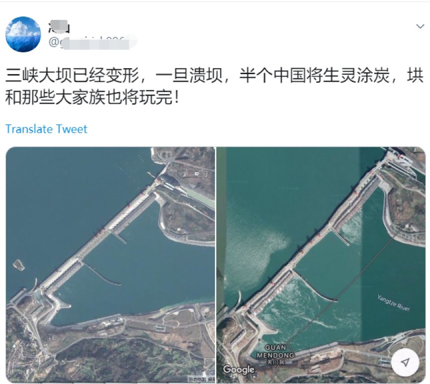
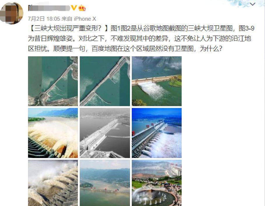
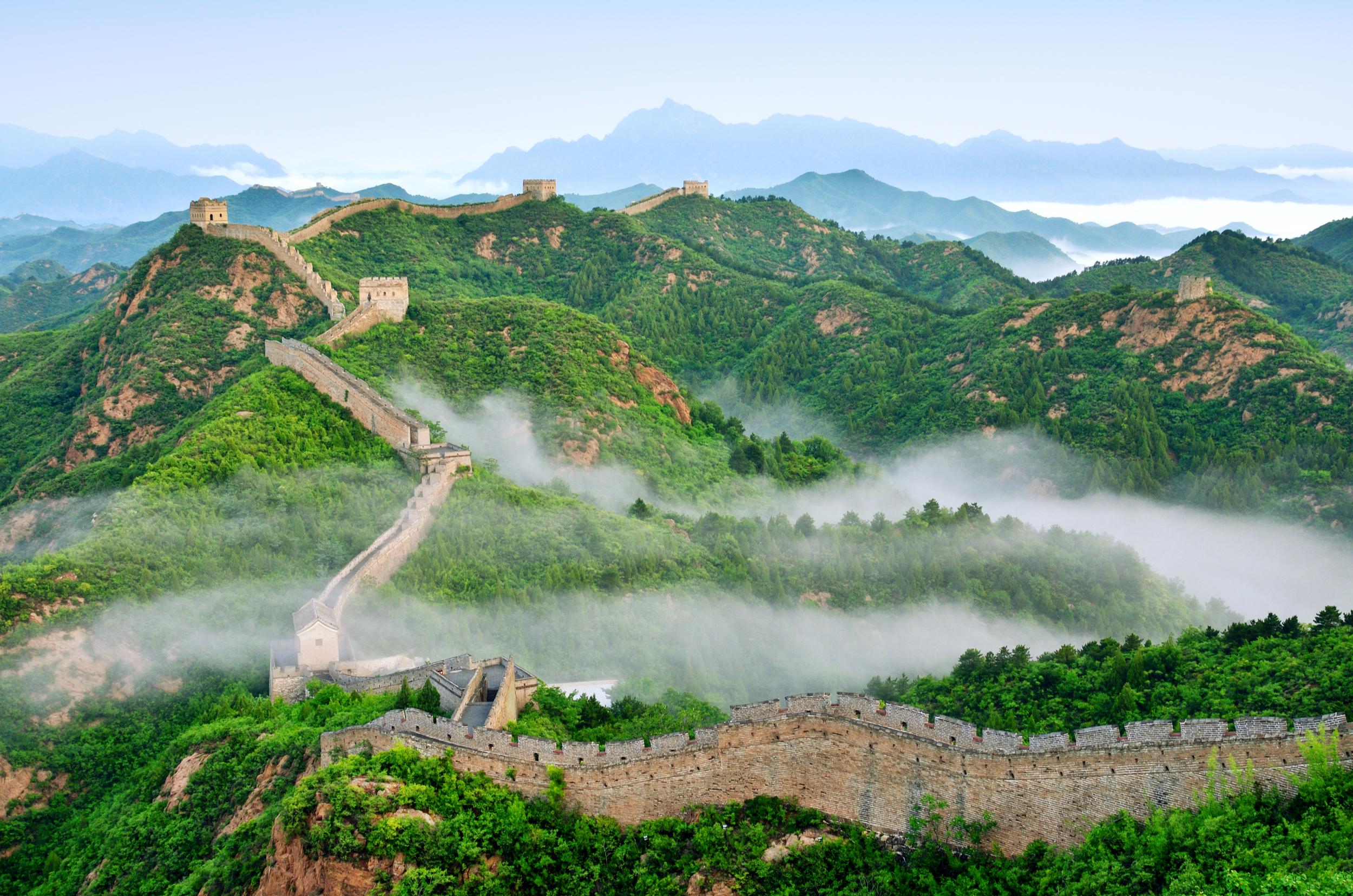
近日,境外一名反华分子在他的社交账号上宣称中国的三峡大坝已经变形,溃堤在即。
但讽刺的是,不仅境内的网民都被他这条谣言给逗笑了,就连境外他的一些同党都看不下去了…。。
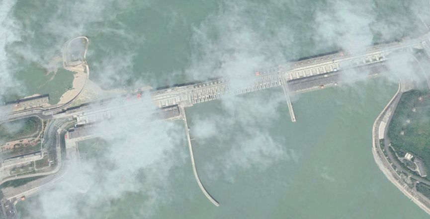
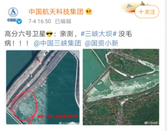
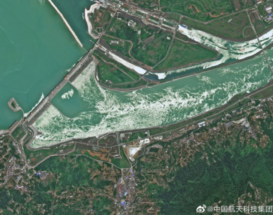
然而尴尬的是,就是这么一则极度弱智的谣言,居然还被人“进口”到了境内的微博上,逼得中国航天科技集团专门拿出的一张高分辨率低轨光学遥感卫星高分六号卫星的图像出来特意澄清了此事。
事情的经过是这样的,就在3天前的7月1日,境外一个反华账号突然发帖宣称“三峡大坝已经变形,一旦溃堤,半个中国将生灵涂炭”。

6f51-hzmafvm1767820.jpg


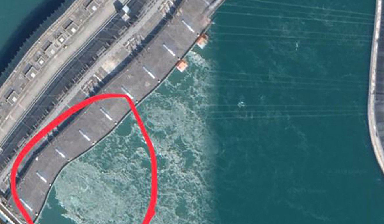
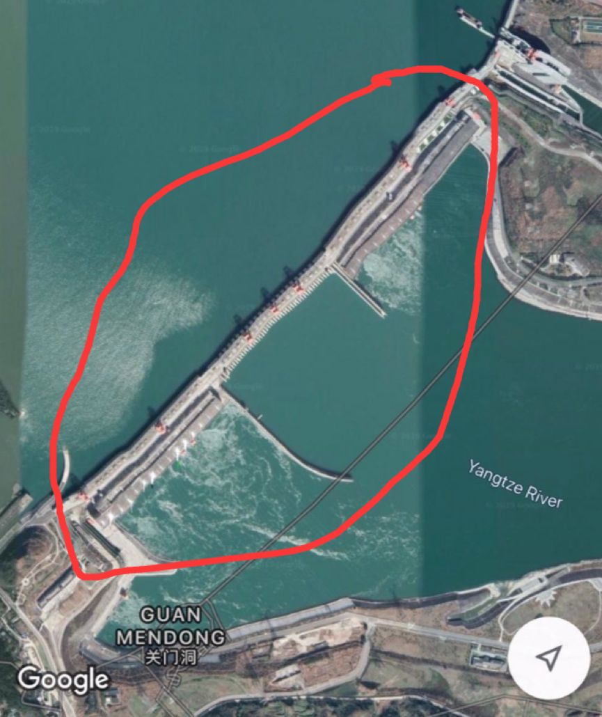
他的“证据”则是美国谷歌公司通过其商业合作伙伴的一颗民用卫星对三峡拍下的一张歪歪扭扭的卫星图片:

fd9b-hzmafvm1767997.jpg


不过,这个谣言贴很快在境外就遭到了不少人的质疑。有人提出民用卫星图片的精确度、图片拍摄的角度和拼接成像时的算法,都会导致图像出现变形。

911f-hzmafvm1768086.jpg


2358-hzmafvm1768151.jpg


8d50-hzmafvm1768194.jpg


6702-hzmafvm1768242.jpg


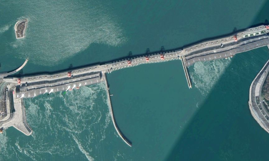
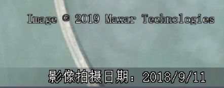
耿直哥也进一步核实发现,这张被用来造谣“三峡变形”的谷歌卫星地图,拍摄于2018年的2月23日,但谷歌地图在2018年9月拍摄的另一张图片则显示三峡一切正常。

980f-hzmafvm1768288.jpg


f075-hzmafvm1768351.jpg

(图为拍摄于2018年2月23日“变形”的卫星图)


3bde-hzmafvm1768411.jpg


8078-hzmafvm1768727.jpg

(图为2018年9月11日相对正常的卫星图)

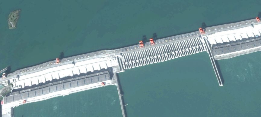
另外,谷歌地图在2016年6月17日和8月12日拍摄的图片也显示三峡一切正常,尽管也有一些拼接的痕迹,而11月拍摄的图片则出现了一定程度上的成像变形。

afec-hzmafvm1768889.jpg


3baf-hzmafvm1768926.png

(图为2016年8月12日相对正常的卫星图)


9659-hzmafvm1768952.jpg


0c2e-hzmafvm1769061.jpg

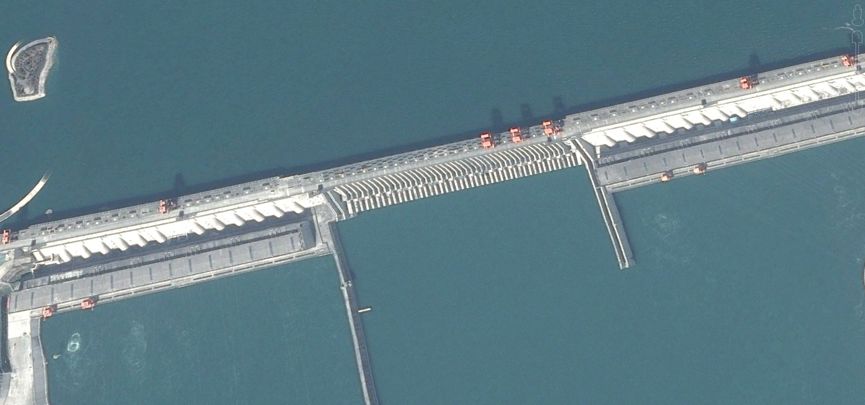
(图为2016年2月27日相对正常的卫星图)


72a7-hzmafvm1769108.jpg


2f53-hzmafvm1769151.jpg

(图为2016年11月12日又有些变形的卫星图)

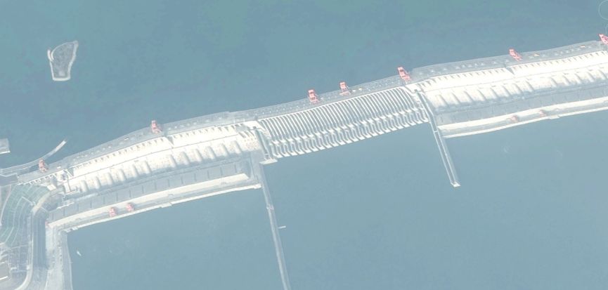
最夸张的一张谷歌的卫星图拍摄于2015年,从这张图中大家可以明显看到这张卫星图片的成像已经严重扭曲了。

6f3b-hzmafvm1769174.jpg


ec22-hzmafvm1769209.jpg


可为啥谷歌公司及其商业合作伙伴的民用卫星拍摄的三峡大坝的图片,会有这么大的偏差呢?
据一位不愿透露姓名的航天遥感专家介绍:
谷歌地图之所以会出现这种情况,主要原因还在于谷歌地图所使用的美国航天技术公司Maxar Technologies遥感卫星影像本身出现了“技术问题”。
通常而言,遥感卫星在成像的时候,有时会因为航天器的姿态、速度、地球曲率、地球自转、地形起伏以及地表人工建筑产生的巨大大高差等因素的影响,造成图像发生一些畸变,这些畸变就集中表现为图像的扭曲、偏移等。要去掉这些畸变就需要采用精准的地表高程模型、精准的参考数据和精准的几何纠正算法对影像进行正射纠正。如果参考数据或者算法不准都会引起影像的畸变。
而在谷歌地球拍摄的这张卫星影像中,由于三峡大坝是一座海拔185米高的巨型人工建筑,如果没有使用精确的,或者根本就没有使用数字高程模型对遥感影像进行“矫正”的话,出现这种扭曲的效果就一点不奇怪了。
所以读到这里,大家再看这条所谓的三峡大坝“变形”的谣言,必然会觉得非常弱智了。
可尴尬的是,即便境外的不少网民早就已经看出来这个谣言很白痴,这条谣言——就像其他许多无脑的反华谣言一样——还是被人“进口”到了境内的微博等社交平台上,并引起了一些不明真相的网民的“哀叹”。

c646-hzmafvm1769233.jpg


9707-hzmafvm1769290.jpg


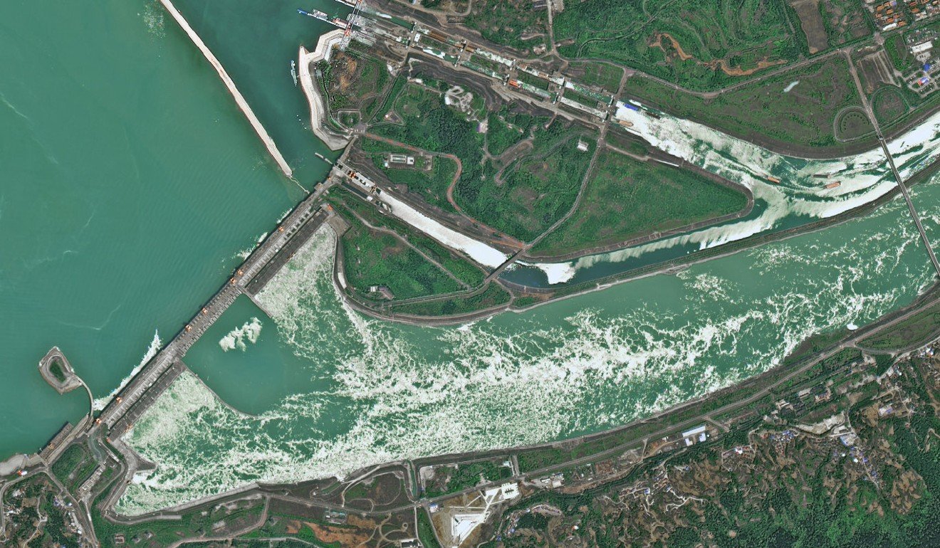
结果,常年遭受境外各种抹黑中国航天谣言摧残的中国航天科技集团,又专门拿出我国高分辨率、高质量成像、高效能成像的“高分六号”卫星,以一种“用牛刀杀鸡”的方式,展现了并无异常的三峡大坝的图片,再一次澄清了此事。

3528-hzmafvm1769320.jpg


8cda-hzmafvm1769361.jpg


最后,那个最初造谣此事的境外反华分子,目前也被其“同党”觉得太丢人了,提醒他说“反华不能造谣”。
可不造谣的话,你们还靠什么反华呢……?

4d5f-hzmafvm1769407.jpg


而主动进行辟谣的中国航天科技集团也借此圈粉无数,很多人表示,很遗憾是通过辟谣的方式才知道我国的光学遥感卫星分辨率居然这么高。

dff1-hzmafvm1769438.jpg


6e34-hzmafvm1769481.jpg


94d6-hzmafvm1769515.jpg


还有网友表示这个辟谣真的太高级了,居然都惊动高分卫星了,如果连这个也不信,那只好再次求助于中国航天科技集团把别有用心造谣传谣的人送上天亲眼查验了。

2643-hzmafvm1769562.jpg


1f6d-hzmafvm1769626.jpg


98b3-hzmafvm1769667.jpg


8e09-hzmafvm1769712.jpg


责任编辑:余鹏飞


Domestic News>Text
Anti-China elements took the Three Gorges Dam and the result was seen by China Aerospace.
July 4, 2019 22:44 Global Times
0

Original title: Anti-China elements took the Three Gorges Dam to do things, and the results were seen by China Aerospace...

Recently, an anti-China element outside the country claimed on his social account that China’s Three Gorges Dam has been deformed and the embankment is just around the corner.

But the irony is that not only the netizens in the country are laughed at by his rumors, but even some of his other parties outside the country can't stand it... .

However, what is embarrassing is that such a very ill-advised rumor has actually been "imported" into Weibo on the territory, forcing the Chinese Aerospace Science and Technology Group to produce a high-resolution low-orbit optical remote sensing satellite with high scores. The image of the No. 6 satellite came out to clarify the matter.

The passage of the matter was like this. Just on July 1st, three days ago, an anti-China account suddenly posted a message stating that “the Three Gorges Dam has been deformed. Once the embankment breaks, half of China will be squandered.”

His "evidence" is a picture of a twisted satellite taken by the US company through a civilian satellite of its business partner to the Three Gorges:

However, this rumor posted quickly outside the country has been questioned by many people. It has been suggested that the accuracy of the civilian satellite image, the angle of the picture and the algorithm used in the stitching imaging will cause the image to be distorted.

He Zhige also further verified that this Google satellite map, which was used to make the "Three Gorges Deformation", was shot on February 23, 2018, but another picture taken by Google Maps in September 2018 shows everything in the Three Gorges. normal.
(The picture shows a satellite image taken on February 23, 2018, "Deformation") (The picture shows a satellite image taken on February 23, 2018, "Deformation")


(The picture shows a relatively normal satellite image on September 11, 2018) (The picture shows a relatively normal satellite image on September 11, 2018)


In addition, the pictures taken by Google Maps on June 17 and August 12, 2016 also showed that the Three Gorges were all normal, although there were some stitching marks, and the pictures taken in November showed some degree of imaging distortion.
(The picture shows the relatively normal satellite image on August 12, 2016) (The picture shows the relatively normal satellite image on August 12, 2016)


(The picture shows the relatively normal satellite image on February 27, 2016) (The picture shows the relatively normal satellite image on February 27, 2016)


(The picture shows a satellite image with some distortions on November 12, 2016) (The picture shows a satellite image with some deformations on November 12, 2016)


The most exaggerated piece of Google's satellite image was taken in 2015. From this picture, you can clearly see that the imaging of this satellite image has been seriously distorted.

Can there be such a big deviation from the pictures of the Three Gorges Dam that was shot by the private satellites of Google Inc. and its business partners?

According to an aerospace remote sensing expert who asked not to be named:

The main reason for this happening in Google Maps is that the US aerospace technology company Maxar Technologies remote sensing satellite imagery used by Google Maps itself has "technical problems."

Generally speaking, when the remote sensing satellite is imaged, it sometimes causes some distortion of the image due to factors such as the attitude, speed, curvature of the earth, the rotation of the earth, the terrain fluctuations, and the huge height difference caused by the artificial buildings on the surface. These distortions are concentrated in the distortion, offset, etc. of the image. To remove these distortions, it is necessary to use an accurate surface elevation model, accurate reference data, and precise geometric correction algorithms to orthorect the image. If the reference data or algorithm is not accurate, it will cause distortion of the image.

In this satellite image taken by Google Earth, since the Three Gorges Dam is a giant artificial building at an altitude of 185 meters, if the accuracy is not used, or the digital elevation model is not used to "correct" the remote sensing image, it appears. This distortion is not surprising.

So reading this, everyone will look at this rumor of the so-called "deformation" of the Three Gorges Dam, and it will certainly feel very mentally handicapped.

What is embarrassing is that even though many netizens abroad have already seen this rumor very idiotic, this rumor - just like many other brainless anti-China rumors - is still "imported" into the territory of Weibo, etc. On the social platform, it has caused some "laments" of netizens who do not know the truth.

As a result, the Chinese Aerospace Science and Technology Group, which has been ravaged by various Chinese rumors of Chinese space rumors all the year round, has specially produced the high-resolution, high-quality imaging and high-performance imaging of the "High Score 6" satellite in China. The way of the chicken shows a picture of the Three Gorges Dam without any abnormalities, once again clarifying the matter.

In the end, the overseas anti-China elements who initially provoked the matter were also considered too shameful by their "comrades" and reminded him that "anti-China can't make a fuss."

If you don’t know what to do, what anti-China do you rely on...?

The China Aerospace Science and Technology Group, which has taken the initiative to blame, has also used this to countless numbers. Many people said that it is regrettable that the resolution of China's optical remote sensing satellites is so high through rumors.

Some netizens said that this rumor was really too advanced, and they all alarmed the high-scoring satellite. If they didn't even believe this, they would have to resort to the China Aerospace Science and Technology Group to send the ulterior motives to the heavens.

Editor in charge: Yu Pengfei
 

Tony Tan

Alfrescian
Loyal

Most likely the HK Idiot or Taiwan Idiots are those making joker of themselves propagating Chow Ang Moh's DISTORTED SATELLITE PICS like FOOLS! Desperate SUCKERS!


Hypocrite-The

Alfrescian
Loyal
The Three Gorges Dam was the pet project of Li Peng, the Butcher of Tiananmen Square.

It would be cosmic irony if the CCP regime were brought down by a burst dam. :wink:
Well said, it would have been cheaperer betterer fasterer and saferer for all and the environment if several smaller dams were built instead of 1 big dam. Just a hay day from the Soviet Union where massive n big show case projects were build to show off to the rest of the world. In addition how about the millions displaced to make way for the dam?
 

tun_dr_m

Alfrescian
Loyal
Well said, it would have been cheaperer betterer fasterer and saferer for all and the environment if several smaller dams were built instead of 1 big dam. Just a hay day from the Soviet Union where massive n big show case projects were build to show off to the rest of the world. In addition how about the millions displaced to make way for the dam?

A true native natural regime only GETS STRONGER WHEN IT LET MORE PEOPLE DIE, instead of PAMPERED. CCP & Most Communists & Islamic Regime are good example. The more death toll they delivered THE STRONGER AND FIRMER AND SECURE IT GETS and they will thus LAST LONGER. They will be gone once they became kind. This UNIVERSAL GOLDEN RULE OF POLITICS! Never changed and STUPID to ATTEMPT TO CHANGE THIS. CCP staved and war billions of death to become superpower. They know this art like MASTERS. Stupid Human Right Democracy Freedom Chow Ang Moh will never learn. They fail to know how & why they are such pathetic failures! During their Crusade Invasion and Carnage times they were growing up. During Slavery Ages, they enslaved Niggers, and developed, During Colonial Century they INVADED & OCCUPIED & Prosper via Imperialism. During Opium War era they strengthen further by being ROYAL DRUG CARTELs. During World Wars they became superpower. Now they eat shit and talked Global Peace & Global Economies & Humanity == THEY TURNED INTO BANKRUPTED BEGGARS & DRUG ADDICTS! MAGA & HUAT AH!

If Dam could collapse and caused carnage, CCP power will rise higher, and be certain to start war and carnage in at the very least Taiwan, if further will be nuking USA.
 

Leongsam

High Order Twit / Low SES subject
Admin
Asset
Anything that is built by the Chinese is not going to last for long.
 

Ang4MohTrump

Alfrescian
Loyal
This is why must not use Google and must use Huawei, you see?

I often noticed Google Map Wrapped roads and runways, and this is what I got this morning of Senai Airport. Click the following URL to view:

https://www.google.com/maps/@1.6065818,103.6755961,1112a,35y,352.56h,75.61t/data=!3m1!1e3


Senai-Runway-Warped-Google-Map.jpg


The white lines on runway is all the way wrapping, and at the lower portion even fragmented and appeared shattered!

I had seen Changi Airport appearing the same, and more than half a dozen other airports!

Chow Ang Moh satellite technologies are far behind Chinese, all alike ABNN Ah Neh standard!
 

Ang4MohTrump

Alfrescian
Loyal

Ang4MohTrump

Alfrescian
Loyal
Therefore, Chow Ang Moh Technology is crap! Chow Ang Moh Satellites are fucked up and falling off the sky any time!
 

JustLikeThis

Alfrescian
Loyal

Hypocrite-The

Alfrescian
Loyal
There's a few good bit that were restored for tourists but the majority of the great wall isn't so great anymore.

View attachment 60943
Open main menu
Wikipedia Search
Mausoleum of the First Qin Emperor
Read in another language
Watch this page
Edit
The Mausoleum of the First Qin Emperor (Qin Shi Huang) (Chinese: 秦始皇陵; pinyin: Qínshǐhuáng Líng) is located in Lintong District, Xi'an, Shaanxi province of China. This mausoleum was constructed over 38 years, from 246 to 208 BC, and is situated underneath a 76-meter-tall tomb mound shaped like a truncated pyramid.[1] The layout of the mausoleum is modeled on the Qin capital Xianyang, divided into inner and outer cities. The circumference of the inner city is 2.5 km (1.55 miles) and the outer is 6.3 km (3.9 miles). The tomb is located in the southwest of the inner city and faces east. The main tomb chamber housing the coffin and burial artifacts is the core of the architectural complex of the mausoleum.

Mausoleum of Qin Shi Huang
秦始皇陵
秦始皇帝陵·秦始皇陵·西安臨潼·(封土正北側).jpg
Mausoleum of the First Qin Emperor is located in ChinaMausoleum of the First Qin Emperor
General information
Location
Lintong District, Xi'an, Shanxi
Country
China
Coordinates
34°22′54″N 109°15′14″E
UNESCO World Heritage Site
Type
Cultural
Criteria
i, iii, iv, vi
Designated
1987 (11th session)
Reference no.
441
State Party
China
Region
Asia-Pacific
The tomb itself has not yet been excavated. Archaeological explorations currently concentrate on various sites of the extensive necropolis surrounding the tomb, including the Terracotta Army to the east of the tomb mound.[2] The Terracotta Army served as a garrison to the mausoleum and has yet to be completely excavated.[3][4]

History
Edit

Work on the mausoleum began soon after Emperor Qin ascended the throne in 246 BC when he was still aged 13, although its full-scale construction only started after he had conquered the six other major states and unified China in 221 BC. The source of the account of the construction of the mausoleum and its description came from Sima Qian in chapter six of his Records of the Grand Historian, which contains the biography of Qin Shi Huang:

In the ninth month, the First Emperor was interred at Mount Li. When the First Emperor first came to the throne, the digging and preparation work began at Mount Li. Later, when he had unified his empire, 700,000 men were sent there from all over his empire. They dug through three layers of groundwater, and poured in bronze for the outer coffin. Palaces and scenic towers for a hundred officials were constructed, and the tomb was filled with rare artifacts and wonderful treasure. Craftsmen were ordered to make crossbows and arrows primed to shoot at anyone who enters the tomb. Mercury was used to simulate the hundred rivers, the Yangtze and Yellow River, and the great sea, and set to flow mechanically. Above were representation of the heavenly constellations, below, the features of the land. Candles were made from fat of "man-fish", which is calculated to burn and not extinguish for a long time. The Second Emperor said: "It would be inappropriate for the concubines of the late emperor who have no sons to be out free", ordered that they should accompany the dead, and a great many died. After the burial, it was suggested that it would be a serious breach if the craftsmen who constructed the mechanical devices and knew of its treasures were to divulge those secrets. Therefore after the funeral ceremonies had completed and the treasures hidden away, the inner passageway was blocked, and the outer gate lowered, immediately trapping all the workers and craftsmen inside. None could escape. Trees and vegetations were then planted on the tomb mound such that it resembles a hill.

— Sima Qian, Shiji, Chapter 6.[5][6]
Some scholars believe that the claim of having "dug through three layers of groundwater" to be figurative.[7] It is also uncertain what the "man-fish" in the text refers to, interpretation of the term varies from whale to walrus and other aquatic animals such as giant salamander.[8][9]

Before the Mausoleum of the First Qin Emperor was completed, a peasant rebellion broke out during the late Qin dynasty. Zhang Han redeployed all the 700,000 people building the mausoleum to suppress the rebellion, so the construction of the mausoleum ceased. After Xiang Yu entered Xianyang, he is said to have looted the tomb. Afterwards, it is said that a shepherd unintentionally burnt down the tomb.[10] The story goes that he went into the dug pit of the mausoleum, dug by Xiang Yu, to look for his sheep with a torch in his hand, and a fire was started, burning away the tomb structures.[11][12] No solid evidence of the destruction of the tomb has been found, although evidence of fire damage has been found in the pits housing the Terracotta Army.[13] Some scholars think that the mausoleum did not suffer any large-scale destruction.

In 1987, the mausoleum, including the Terracotta Warriors, was listed as World Heritage Sites.[14]

Discovery of the Terracotta Warriors

Archaeological studies

Opinions on possible excavation

References

External links

Last edited 2 months ago by Chewings72
RELATED ARTICLES
Terracotta Army
collection of ancient Chinese military statues
Lintong District
District in Shaanxi, People's Republic of China
Tomb of Wang Jian
Tomb of Wang Jian, emperor of Former Shu
Wikipedia

Content is available under CC BY-SA 3.0 unless otherwise noted.
Terms of UsePrivacyDesktop
 
Top