$150 million to be spent on drainage upgrading works in FY2025 to guard against floods
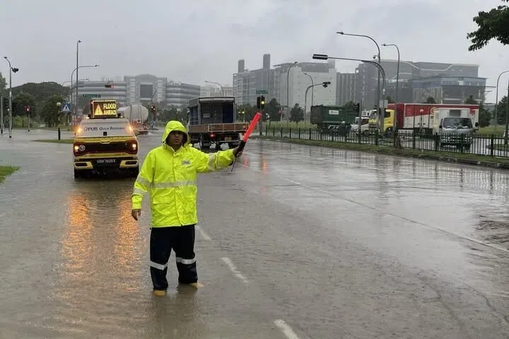
A car passing through a flooded low-lying section of Mountbatten Road connecting Jalan Seaview on Jan 10.
Feb 04, 2025
SINGAPORE – Some $150 million will be spent on drainage development works in the 2025 financial year as part of efforts to reduce flash floods, Minister for Sustainability and the Environment Grace Fu told Parliament on Feb 4.
Six new projects, to start in 2025, will include works on the Bedok First Subsidiary Drain and roadside drain improvement works in Frankel Estate near Siglap.
There are another 19 ongoing drainage upgrading projects, she said.
These include the Syed Alwi Pumping Station – to reduce flooding in the low-lying Jalan Besar area – and improvements to Bukit Timah canal, to widen and deepen a 900m stretch from Rifle Range Road to Jalan Kampong Chantek.
The Bukit Timah area has been flood-prone for decades.
With $2.5 billion spent on improving drainage infrastructure since 2011, Ms Fu said her ministry is currently reviewing the country’s drainage infrastructure plan for the next review cycle between 2026 and 2030.
The minister was responding to questions by three MPs on her ministry’s plans to improve Singapore’s drainage system, given the recent flooding episodes caused by a monsoon surge in January 2025.
Singapore experienced two monsoon surge events from Jan 10 to 13 and Jan 17 to 19.
A monsoon surge refers to bursts of cold air from the north-east, such as Central Asia, which flow over the South China Sea before bringing widespread rainfall, strong winds and cooler weather to Singapore.
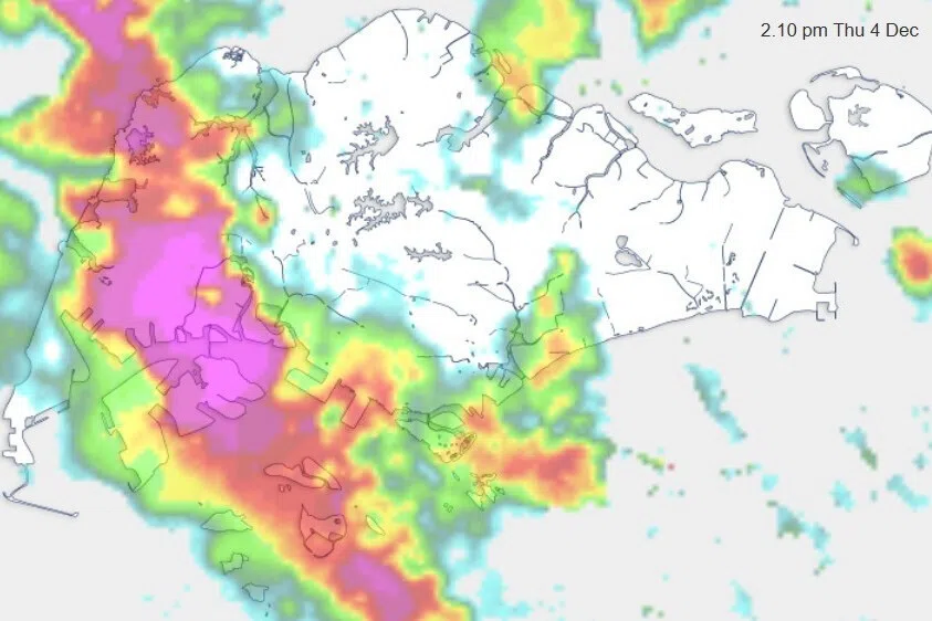
During the first monsoon surge, a total of 255.2mm of rainfall was recorded in Changi between Jan 10 and 11, which exceeded the country’s average monthly rainfall for the month.
The rainfall event on Jan 10 led to a nearly
three-hour flood at a side road bend of Jalan Seaview in Mountbatten, said Ms Fu, as the prolonged rain coincided with high tide.
The flooding on the road was about 0.3m high, and a house next to the road experienced flooding within its car porch area.
In the past five years, this is the only stretch of road along Jalan Seaview that has experienced flooding, she added.
However, despite having a tidal gate in place since the 1980s and increasing the capacity of the roadside drains in 2014, some areas near Jalan Seaview are still susceptible to flooding, as the road levels are marginally above the high tide level, said Ms Fu.
The tidal gate at an outlet drain near Jalan Seaview was built to control water from the sea flowing into the drains during high tide.
Mr Desmond Choo (Tampines GRC) later asked about the types of interim measures available, such as pumps, that can be deployed quickly during flooding incidents.
“Whether pumps will be really effective in the case of Jalan Seaview, that may be doubtful, because we’re talking about the coincidence of both intense rain and high tide.
“So it’s difficult to pump something out if the tide is against you,” said Ms Fu.
“The longer-term plan is to reclaim and build Long Island which will protect the East Coast area, including Jalan Seaview, from rising sea levels and tidal floods,” she added.
Long Island is a planned offshore development that aims to protect the low-lying East Coast area while providing new amenities and land space for Singapore.
This offshore defence against rising seas could create 800ha of reclaimed land off East Coast Park, with a reservoir in between.
Higher sea levels, when coupled with high tides and intense rainfall, could worsen coastal flooding in the future.
Ms Fu said government agencies have initiated technical studies and are engaging the public and stakeholders to shape the plans for this future mega project.
Singapore’s flood-prone areas make up less than 25ha today, down from about 3,200ha in the 1970s.
While the country has been continually upgrading its drainage infrastructure, “it is neither practical nor prudent in land-scarce Singapore to keep building more drains or expanding our drainage infrastructure”, the minister told the House.
“Doing so would require significant land and financial resources, which would then not be available for other important uses,” she added, reiterating that the Government, building owners and developers, as well as the wider community, should do their part to be prepared for flash floods and adapt to them.
Ms Fu added that it is not financially wise for the country to prepare for rare extreme weather events that have significant impacts – so-called high-impact, low-likelihood events – because they may not occur regularly.
And taking measures to prevent those events will require more resources.
“So it is still the same message: While the Government will look at improving our infrastructure, we need (the) community, businesses, owners to also undertake protection measures to protect themselves, their properties and their families.”
Currently, flooding in Singapore is localised and typically subsides within an hour in most instances.
There is a surface water drainage protocol that spells out requirements on minimum platform and crest levels for buildings, and flood protection measures that building owners and developers must implement to protect their premises.
At the community level, national water and coastal protection agency PUB reaches out to residents and businesses in flood-prone areas before the north-east monsoon season – for example, to distribute flood protection gear such as flood barriers and inflatable sand bags.
The authorities also forecast intense rainfall and put out early warnings of potential floods to alert the public, so that they can avoid low-lying areas.
Mr Saktiandi Supaat (Bishan-Toa Payoh GRC) asked how PUB is working with other agencies to enhance flood resilience, and whether residents and businesses affected by floods can get financial and logistical support.
Ms Fu said PUB and the National Environment Agency are improving forecasts for intense rainfall, to zero in on specific places that are likely to get flooded in future weather events.
PUB is also working with the Land Transport Authority to alert commuters about flooded roads earlier, and possibly incorporate such advisories in the next-generation Electronic Road Pricing system.
“We will offer more help, and we will keep very close contact with the public and with businesses when it comes to engaging them on the deployment of flood protection devices,” said Ms Fu.