
- Joined
- Nov 28, 2012
- Messages
- 119
- Points
- 0
Massive line of storms puts one in five in US at risk for severe weather
Meteorologists from Chicago to Washington warn system could be the 'worst severe weather outbreak' of the year
Associated Press in Chicago
The Guardian, Wednesday 12 June 2013 21.12 BST
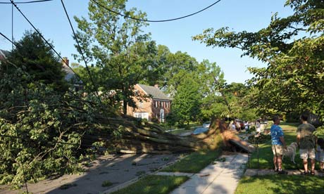
A derecho last June left millions of people around Washington DC without power for days. Photograph: Mandel Ngan/AFP/Getty Images
An unusually massive line of storms packing hail, lightning and tree-toppling winds could affect more than one in five Americans on Wednesday as it rolls from Iowa to Maryland.
Meteorologists were even warning about the possibility of a weather event called a derecho, which is a storm of strong straight-line winds spanning at least 240 miles. The storms are also likely to generate tornadoes and cause power outages that will be followed by oppressive heat, said Russell Schneider, director of the National Weather Service's storm prediction center in Norman, Oklahoma.
"We're becoming increasingly concerned that a major severe weather event will unfold," Schneider said. "The main thing is for folks to monitor conditions and have a plan for what to do if threatening weather approaches."
For the first time this year, the center was using its highest alert level for parts of Iowa, Illinois, Indiana and Ohio. The storms will start in the late afternoon in eastern Iowa, Schneider said, and could hit Chicago around rush-hour.
The area the weather service considers to be under heightened risk of dangerous weather includes 74.7 million people in 19 states.
Wednesday "might be the worst severe weather outbreak for this part of the country for the year," said Jeff Masters, meteorology director at Weather Underground.
Tornadoes and a derecho can happen at the same time, but at any given place on Wednesday the straight-line winds are probably more likely. Straight-line winds lack the rotation that twisters have, but they can still cause considerable damage as they blow down trees and other objects.
"Be prepared to move away from windows," Schneider said. Listen for weather warnings and go into a basement, if possible, and get underneath a study object like a table, he said, if a tornado warning is issued. "You want to know where your family's at so everyone can get to safety successfully."
Last year, a derecho caused at least $1bn in damage from Chicago to Washington, killing 13 people and leaving more than 4 million without power, according to the weather service. Winds reached nearly 100mph in some places and in addition to the 13 people who died from falling trees, an additional 34 people died from the heat wave that followed in areas without power.
Derechoes, with winds of at least 58mph, occur about once a year in the mid-west. Rarer than tornadoes but with weaker winds, derechoes produce damage over a much wider area.
Wednesday's storm probably won't be as powerful as 2012's historic one, but it is expected to cause widespread problems, said Bill Bunting, operations chief at the National Weather Service's Storm Prediction Center.
The storms will move so fast that "by the time you see the dark sky and distant thunder you may have only minutes to get to safe shelter", Bunting said.
For Washington, Philadelphia and parts of the mid-Atlantic the big storm risk continues and may even increase on Thursday, according to the weather service.
The term derecho was coined in 1888, said Ken Pryor, a research meteorologist at the Center for Satellite Applications and Research at the National Oceanic and Atmospheric Administration in College Park, Maryland. The word is Spanish for straight ahead or direct, Pryor said.
The structure of a derecho-producing storm looks distinctive in radar and satellite imagery, Pryor said. "The systems are very large and have signatures that are very extreme," he said. "You get large areas of very cold cloud tops that you typically wouldn't see with an ordinary thunderstorm complex. The storms take on a comma or a bow shape that's very distinctive."