• IP addresses are NOT logged in this forum so there's no point asking. Please note that this forum is full of homophobes, racists, lunatics, schizophrenics & absolute nut jobs with a smattering of geniuses, Chinese chauvinists, Moderate Muslims and last but not least a couple of "know-it-alls" constantly sprouting their dubious wisdom. If you believe that content generated by unsavory characters might cause you offense PLEASE LEAVE NOW! Sammyboy Admin and Staff are not responsible for your hurt feelings should you choose to read any of the content here.

    The OTHER forum is HERE so please stop asking.

El Nino to end by June, La Nina seen in second half of 2024, says U.S. forecaster

meaninglesslife

Stupidman
Loyal

El Nino to end by June, La Nina seen in second half of 2024, says U.S. forecaster​

Reuters
Thu, May 9, 2024, 10:13 PM GMT+82 min read

May 9 (Reuters) - The El Nino weather pattern should fade out by June but could be replaced by the La Nina phenomenon by the second half of the year, a U.S. government forecaster said on Thursday.

There is a 49% chance that the La Nina weather pattern may develop during the June to August period, rising to 69% in July-September, the National Weather Service's Climate Prediction Center (CPC) said in its monthly forecast.

WHY IT'S IMPORTANT

The cycle between the weather patterns -- which can spawn wildfires, tropical cyclones and prolonged droughts -- is vital to farmers worldwide.

In Latin America, they have affected crops such as wheat, soy and corn, damaging regional economies often highly dependent on farming.

Hot, dry weather in Asia during El Nino last year prompted top rice supplier India to restrict exports following a poor monsoon, while wheat output in No.2 exporter Australia took a hit. But heavier rains in parts of the Americas boosted farm output prospects in Argentina and the southern U.S. Plains.

CONTEXT

The full weather pattern involving El Nino, La Nina and a neutral phase typically lasts between two to seven years.

Experts have warned that Latin American nations must be on high alert as a rapid switch to La Nina this time could leave populations and crops little time to recover.
Australia's weather bureau said last month that the El Nino event has ended.

KEY QUOTES

"La Nina is likely to affect the production of wheat and corn in the US, and soybean, barley, wheat and corn in Latin America including Brazil, Argentina and Uruguay," said Sabrin Chowdhury, head of commodities at BMI.

"The weather phenomenon is associated with long-lasting droughts throughout the Americas region, triggering poor crop quality and a drop in average yields, further exacerbating global supply issues." (Reporting by Anushree Mukherjee and Brijesh Patel in Bengaluru, Editing by Rosalba O'Brien)
 

meaninglesslife

Stupidman
Loyal
What Is La Niña? | NASA Space Place – NASA Science for Kids
spaceplace.nasa.gov

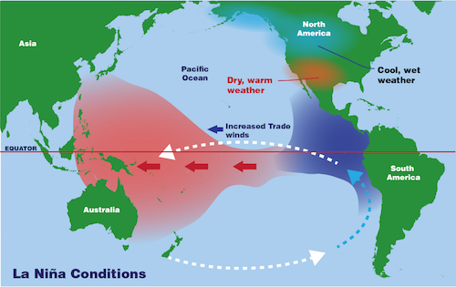
La Niña is a weather pattern that begins in the Pacific Ocean. Warm ocean water and clouds move west during a La Niña. This means that places like Indonesia and Australia can get much more rain than usual. And places like the southwestern United States can be very dry.

The oceans play an important role in Earth's weather. Rain clouds normally form over warm ocean water. When strong winds cause this warm water to move, the clouds and storms move, too.

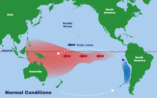
In normal conditions, winds above the Pacific Ocean gently push warm water west. That warm water travels from the west coast of South America all the way to Indonesia. As the warm water moves, cold water from the bottom of the ocean slowly rises up to take its place.

But during La Niña...​

In a La Niña year, the winds above the Pacific Ocean are much, much stronger than usual. This usually happens once every few years. The winds are so strong during a La Niña (Spanish for "the girl") that they push lots of warm ocean water west toward Indonesia. And that means that lots of cold water rises to the surface near South America.

This makes the water in the eastern Pacific Ocean degrees a few degrees colder than usual. Even this small change in the ocean's temperature can affect weather all over the world.

an illustrated map of the water movement in the Pacific Ocean under normal conditions

an illustrated map of the water movement in the Pacific Ocean under La Niña conditions
Drag the slider tool to see the differences between La Niña conditions and normal conditions in the Pacific Ocean.

Warm water moves west during a La Niña, and so do the clouds. This means that places like Indonesia and Australia can get much more rain than usual. And places like the southwestern United States can be very dry. La Niña weather conditions can also lead to more hurricanes and lightning in other parts of the world.

Thankfully, scientists can predict La Niña weather patterns up to a year before they occur. The GOES-R series of weather satellites can help weather forecasters map the increased lightning and issue earlier and more accurate warnings of severe weather.

What's the difference between El Niño and La Niña?​

Both events start in the Pacific Ocean, but they are opposites in almost every other way! La Niña causes water in the eastern Pacific to be colder than usual. In the same region, El Niño can cause the water to be warmer than usual. So, areas that are hit with drought during La Niña years can get lots of rain in El Niño years!
 
Top