Front Page
Taiwan News
Business
Editorials
Sports
World News
Features
Bilingual Pages
Search
Home Features
Mon, Jun 27, 2016 page12
The Emperor’s Mysterious Map and the South China Sea
Is China censoring ancient clues to the secret history of the Spratly Islands?
By John J. Tkacik / Contributing reporter
Within the imperial chambers of the Wanli Emperor (萬曆), sovereign of the Ming Dynasty from 1563 to 1620, could be found an encyclopedic work of cartographic craftsmanship unlike anything existing in Europe.
It was a multicolored world map mounted on a six-paneled folding screen, taller than a man and twice that in width, which transfixed the emperor with the revelation that his own empire, vast as it was, was nevertheless a minor portion of all under heaven. It was said that the emperor himself frequently studied it with intense curiosity and ordered 12 more full-size copies for the palace.
EXTENT OF THE EMPIRE
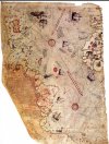
A portion of an original 1602 Ricci Map at the University of Minnesota that has the legend about the Ming Empire’s borders erased.
Photo courtesy of John J. Tkacik
The giant map was entitled Comprehensive Chart of the Myriad Lands upon the Foundation of the Earth (坤輿萬國全圖) and depicted a world 20 times more expansive than the emperor had ever imagined. It bore over 850 place names and minutely scripted legends for each kingdom, island and continent. It featured latitude and longitude lines identifying their locations on the spherical Earth.
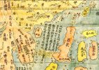
In the map quadrant encompassing what we now know as the South China Sea was the legend, “The Great Ming is renowned for the richness of its civilization. It comprises all between the 15th and 42nd parallels. The other tributary realms of the four seas are very numerous.”
During the late Ming, the northern borders of the empire stopped at the 42nd parallel along the Great Wall that protected China from northern tribes. In the south, the empire ended at the Paracel Islands (Xisha Islands, 西沙群島) on the 15th parallel in the South China Sea, beyond which were the Ming vassal kingdoms of Southeast Asia.
A portion of an 1604 version of the Ricci map with the legend about the Ming Empire’s borders intact.
Photo courtesy of image Database of the Kano Collection, Tohoku University Library and Wikimedia Commons
The map was the collaborative work between an Italian Jesuit missionary in Beijing, Matteo Ricci, and a famed Chinese geographer, Li Wocun (李我存). Li compiled the data points for Ming territories, while Ricci filled in the rest of the world and combined European and Chinese geographic knowledge for the first time in Chinese or in any language.
While the Ricci-Li world maps were famous among Ming officials of the era, Ricci was hesitant to present one to the imperial court.
He reported in his Commentary on China that “the [Jesuit] fathers had never given a copy of the map to the [emperor], nor proffered to do so, lest he, seeing China — which according to the Chinese included the greater part of the world — so small, should be offended, thinking that our people had shown it thus in contempt, such, indeed, being the belief of many Chinese men of letters, who made [com]plaint against us, saying that we enlarged our foreign kingdoms, but made China appear small.”