- Joined
- Aug 28, 2011
- Messages
- 3,990
- Points
- 63
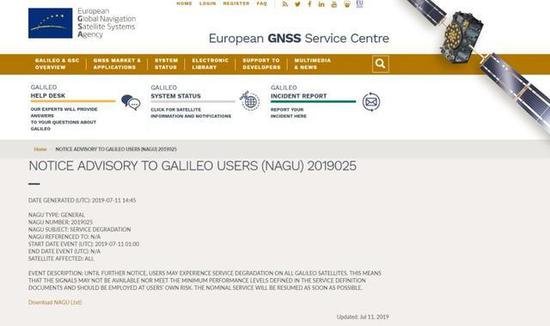
The Galileo are Pentagonal Symbols, and VANISHED from sky as I just verified. The bankrupted beggars Chow Ang Moh after 17 years of effort finally went live in 2016 only 3 yrs ago, with Galileo. And their Signal qualities are degraded so fast! Their web says SERVICE DEGRADATION = ALL 33 satellites!
https://www.gsc-europa.eu/system-status/Constellation-Information
Constellation Information
Constellation Status
Satellite Name1
SV ID2
Clock3
Status4
Active NAGU5
NAGU Type6
NAGU Subject7
GSAT0101
E11
2019025 GENERAL SERVICE DEGRADATION
GSAT0102
E12
2019025
GENERAL
SERVICE DEGRADATION
GSAT0103
E19
2019025 GENERAL SERVICE DEGRADATION
GSAT0104
E20
RAFS
NOT AVAILABLE
2014014
UNP_UNUFN
UNAVAILABLE FROM 2014-05-27 UNTIL FURTHER NOTICE
GSAT0201
E18
PHM
TESTING
2019020
GENERAL
TESTING OF GSAT0201
GSAT0202
E14
PHM
TESTING
2019021
GENERAL
TESTING OF GSAT0202
GSAT0203
E26
2019025
GENERAL
SERVICE DEGRADATION
GSAT0204
E22
RAFS
NOT USABLE
2017045
GENERAL
GSAT0204 REMOVED FROM ACTIVE SERVICE ON 2017-12-08 UNTIL FURTHER NOTICE FOR CONSTELLATION MANAGEMENT PURPOSES
GSAT0205 E24 2019025 GENERAL SERVICE DEGRADATION GSAT0206 E30 2019025 GENERAL SERVICE DEGRADATION GSAT0207 E07 2019025 GENERAL SERVICE DEGRADATION GSAT0208 E08 2019025 GENERAL SERVICE DEGRADATION GSAT0209 E09 2019025 GENERAL SERVICE DEGRADATION GSAT0210 E01 2019025 GENERAL SERVICE DEGRADATION GSAT0211 E02 2019025 GENERAL SERVICE DEGRADATION GSAT0212 E03 2019025 GENERAL SERVICE DEGRADATION GSAT0213 E04 2019025 GENERAL SERVICE DEGRADATION GSAT0214 E05 2019025 GENERAL SERVICE DEGRADATION GSAT0215 E21 2019025 GENERAL SERVICE DEGRADATION GSAT0216 E25 2019025 GENERAL SERVICE DEGRADATION GSAT0217 E27 2019025 GENERAL SERVICE DEGRADATION GSAT0218 E31 2019025 GENERAL SERVICE DEGRADATION GSAT0219 E36 2019025 GENERAL SERVICE DEGRADATION GSAT0220 E13 2019025 GENERAL SERVICE DEGRADATION GSAT0221 E15 2019025 GENERAL SERVICE DEGRADATION GSAT0222 E33 2019025 GENERAL SERVICE DEGRADATION
1: Satellite Name: Galileo Satellite (GSAT) identifier of the satellites:
3: Clock: PHM = Passive Hydrogen Maser, RAFS = Rubidium Atomic Frequency Standard.
4: Status:
6: NAGU Type: information about the type of the applicable NAGU (see NAGU Information section).
7: NAGU Subject: content of the ‘NAGU Subject’ field of the applicable NAGU (see NAGU Information section).
Updated: Jul 12, 2019
NAGU Type NAGU Number Date of start event Date of publication (UTC) NAGU Subject Satellites affected GENERAL 2019025 2019-07-11 01:00 2019-07-11 14:45 SERVICE DEGRADATION ALL GENERAL 2019021 2019-03-23 13:02 2019-05-23 15:30 TESTING OF GSAT0202 GSAT0202 GENERAL 2019020 2019-02-27 06:02 2019-05-23 15:05 TESTING OF GSAT0201 GSAT0201 GENERAL 2017045 2017-12-08 07:30 2017-11-23 17:45 GSAT0204 REMOVED FROM ACTIVE SERVICE FOR CONSTELLATION MANAGEMENT PURPOSES GSAT0204 GENERAL 2016063 2016-12-15 12:00 2016-12-15 12:00 GALILEO INITIAL OPEN SERVICE (OS) DECLARATION ALL SATELLITES WITH USABINIT NAGU ISSUED


https://mil.news.sina.com.cn/china/2019-07-13/doc-ihytcitm1701268.shtml
欧洲伽利略系统"挂了":卫星导航信号无法更新
欧洲伽利略系统"挂了":卫星导航信号无法更新
125
伽利略挂了。不是指伟大的科学家伽利略·伽利雷,而是四大全球卫星导航系统之一的,由欧盟建设的伽利略系统挂了。
据“监测评估中心”报道,伽利略系统在UTC时间2019年7月10日14-15和17时(北京时间7月10日22-23和7月11日01时)出现3个小时的异常,其卫星导航信号的广播星历没有更新。
Part.1
什么是卫星导航系统?
卫星导航系统,简称GNSS系统,它是距离我们一群两万公里的星星,它们不会发光也不会发热,甚至肉眼没有办法观察到它们,为我们提供着位置服务。
在卫星导航系统俱乐部中一共有4位VIP会员,除了欧盟的伽利略系统、大家所熟知的美国GPS系统以外,包括俄罗斯的GLONASS系统、以及我们国家自主建设的北斗卫星导航定位系统。
Part.2
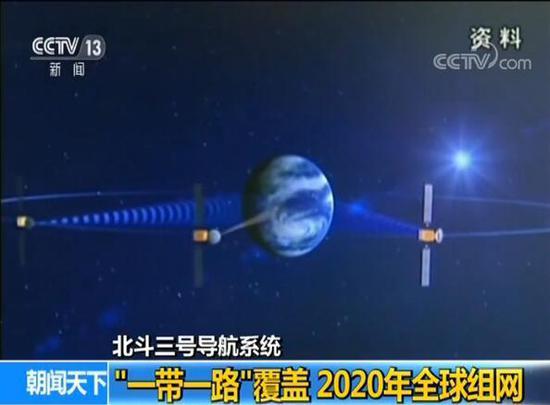
是时候跟你们介绍下北斗卫星导航系统
北斗卫星导航定位系统,由空间段、地面段和用户段三部分组成,是我国自主建设、独立运行的卫星导航系统,是为全球用户提供全天候、全天时、高精度的定位、导航和授时服务的国家重要空间基础设施。
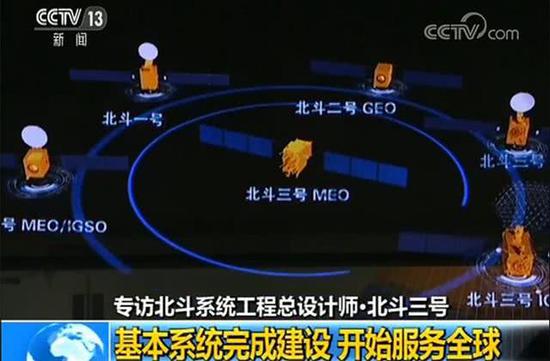
据新华社报道,北斗三号基本系统已完成建设。根据计划,2020年10月前,由北斗二号和北斗三号系统共同提供服务;2020年10月后,将可以说,北斗,不仅是中国的北斗,也是世界的北斗。
中科院光电研究院的徐颖,在中科院SELF格致论道讲坛曾说:“北斗系统从诞生到现在,虽然已经通过多方面证明,精度和可靠性,完全不输GPS导航系统。或许你会问:有GPS了,还要北斗干嘛?事实上,GPS系统并没有想象的那么可靠。因为GPS系统只被我们开放了民码信号,而GPS民码信号战争时候很容易说变就变,为了保障自主权,欧盟建设了伽利略系统。对我们来讲也是如此,为了保障我们的可靠性,国家开始建设属于我们自己的北斗系统。”

Part.3
北斗的应用 只有你想不到
北斗系统不仅能提供位置、导航和授时这样的功能,而且还提供通信功能。
美国GPS之父帕金森教授曾经这样盛赞北斗的导航通信一体化功能:“既能够知道你在哪里,也能够知道我在哪里,这是多么美妙的体验。”
目前北斗已广泛应用于交通运输、海洋渔业、水文监测、气象预报、测绘地理信息、森林防火、通信时统、电力调度、救灾减灾、应急搜救等领域。
北斗亮,中国强!
中国北斗,拥抱全球。
来源:“中国科普博览”公众号(kepubolan)
关键字 : 卫星导航北斗卫星
我要反馈
https://mil.news.sina.com.cn/china/2019-07-13/doc-ihytcitm1771810.shtml
欧洲伽利略导航系统服务中断 卫星信号仍未恢复
欧洲伽利略导航系统服务中断 卫星信号仍未恢复
504
[文/观察者网 赵挪亚]
刚刚具备全部导航功能,欧盟的“伽利略”卫星导航系统就“挂”了……
欧洲全球导航卫星系统局11日发布公告称,从世界标准时间(UTC)7月11日1点开始,用户将经历“伽利略”卫星导航系统的服务中断,信号将不可用,具体恢复时间待定。
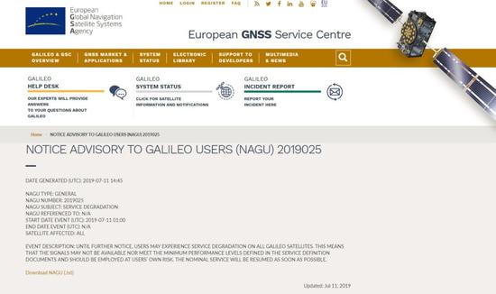
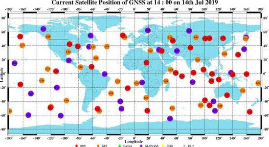
官方11日发布的服务降级公告 图自欧洲全球导航卫星系统局
截止到UTC时间7月12日8时,“伽利略”的服务仍旧未恢复。有监测数据显示,本次服务中断,与卫星导航信号的广播星历确实有关。
导航卫星行业权威杂志“Inside GNSS”12日援引欧洲全球导航卫星系统局内部消息称,团队正在全力恢复“伽利略”的服务,修复工作预计将在当地时间7月13-14日完成。
对于本次服务中断,观察者网评论员施佬分析称,在2019年“伽利略”具备全部导航功能的关键时刻,出现如此重大的事故,毫无疑问会重挫市场对这一系统的信心。
“服务降级”
根据欧洲全球导航卫星系统局11日发布的公告显示,“伽利略”卫星导航系统的服务中断从UTC时间当天1点开始。不过,根据“全球连续监测评估中心”(iGMAS)11日数据显示,从UTC时间7月10日14-15时以及17时起,“伽利略”已经出现异常。
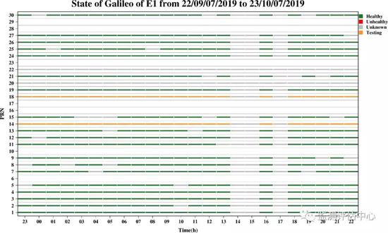
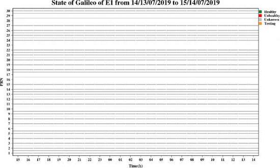
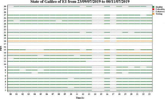
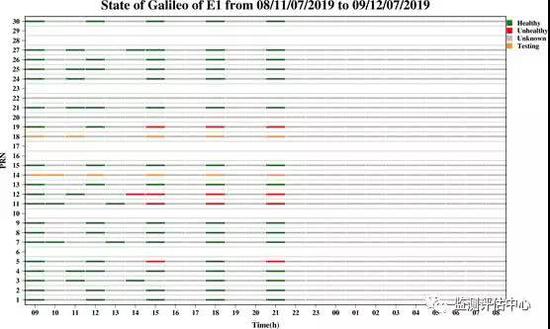
UTC时间10日14-15时和17时,“伽利略”广播星历变灰 图自iGMAS
iGMAS是《中国第二代卫星导航系统重大专项实施方案》明确安排的三大试验系统之一,是对全球四大卫星导航系统运行状况和主要性能指标进行监测和评估,生成高精度精密星历和卫星钟差、地球定向参数、跟踪站坐标和速率、全球电离层延迟等产品的信息平台。而监测评估中心是其重要组成部分。
12日,监测评估中心在其官方微信公众号中表示,UTC时间7月11日21时50分后,“伽利略”系统彻底中断服务,而截至到UTC时间7月12日8时,服务仍旧未恢复。
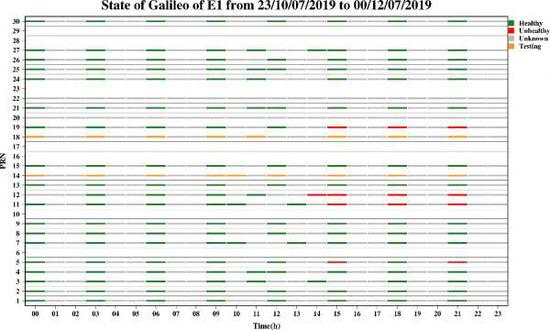
UTC时间7月11日22时开始,全部变灰 图自iGMAS
此外,监测评估中心12日表示,采用iGMAS平台7月11日全天的星历数据分析发现,“伽利略”中断服务后,定位性能下降。通过对比中断前后全球综合结果,发现中断服务后水平方向服务性能下降8%,高程方向下降251%,这也进一步证实了“伽利略”服务性能下降。

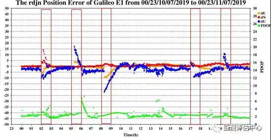
可以明显看到,在“伽利略”中断服务以后,定位计算结果出现明显偏差 图自iGMAS监测评估中心
“伽利略”可靠性堪忧?
“伽利略”定位系统,是一个正在建造中的卫星定位系统,该系统由欧盟通过欧洲空间局和欧洲导航卫星系统管理局建造,是全球四大定位系统之一,其目的在于建立欧洲自己的卫星导航系统,摆脱依赖美国“全球定位系统”(GPS)的局面。
2011年8月21日,“伽利略”首颗卫星发射,该系统计划发射30颗卫星,将于2020年前发射完成。2019年,“伽利略”系统开始具备完全工作能力。

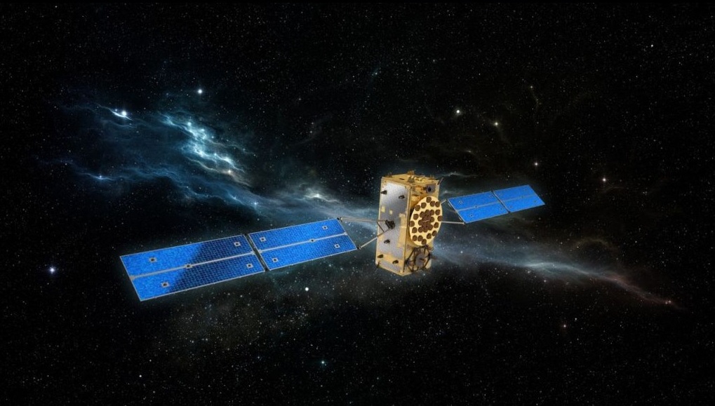
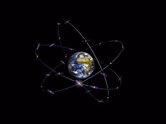
欧盟的“伽利略”定位系统 图自欧洲航天局
根据iGMAS数据显示,本次“伽利略”出现服务中断,其卫星导航信号的广播星历没有更新。
广播星历是由全球定位系统的地面控制部分所确定和提供的,是定位卫星发播的无线电信号上载有预报一定时间内卫星轨道根数的电文信息,经过解码获得的卫星星历推算得到卫星位置,目前广播星历主要用于导航定位和低等级的工程测量。
广播星历数据中断,表明现有的“伽利略”系统现有的24颗卫星全部崩溃。
卫星导航系统的精度是基于自身轨道、时间等参数的精准信息,这些信息将通过星历广播给用户。因此,在本次“伽利略”系统出现的故障后,用户无法获得卫星更新的各项参数,这也导致导航的精度下降。
此外,导航星历偶尔缺失,对在使用中的接收机影响不大,因为可以用过期的星历,但如果缺失时间长,精度会发散直至不可用。
对于“伽利略”系统本次发生的数据中断,观察者网评论员施佬分析称:“伽利略系统作为当代全球四大导航系统之一,原本计划在2019年具备全部导航功能,在此关键时刻发生的严重事故毫无疑问将重挫市场对于这套新兴导航系统的信心,加深对其系统可靠性的担忧,影响其未来的推广和应用前景。”
关键字 : 导航卫星中国
我要反馈
Https://mil.news.sina.com.cn/china/2019-07-13/doc-ihytcitm1701268.shtml
European Galileo system "hangs up": satellite navigation signals cannot be updated
European Galileo system "hangs up": satellite navigation signals cannot be updated
125
Galileo hung up. It does not refer to the great scientist Galileo Galilee, but one of the four global satellite navigation systems. The Galileo system built by the European Union hangs.
According to the “Monitoring and Evaluation Center”, the Galileo system experienced a three-hour anomaly at 14-15 and 17:00 on July 10, 2019 UTC time (Beijing time, July 12, 22-23 and July 11, 01:00). The broadcast ephemeris of its satellite navigation signals has not been updated.
Part.1
What is a satellite navigation system?
The satellite navigation system, referred to as the GNSS system, is a group of 20,000 kilometers away from us. They don't emit light or heat, and even the naked eye can't observe them, providing us with location services.
There are a total of 4 VIP members in the satellite navigation system club, in addition to the European Union's Galileo system, the well-known US GPS system, including the Russian GLONASS system, and the Beidou satellite navigation and positioning system built by our country.
Part.2
It’s time to introduce you to the Beidou satellite navigation system.
The Beidou satellite navigation and positioning system consists of three parts: space segment, ground segment and user segment. It is a self-constructed and independent satellite navigation system in China. It provides global users with all-weather, all-day, high-precision positioning, navigation and timing. National critical space infrastructure for services.
According to Xinhua News Agency, the basic system of Beidou No. 3 has been completed. According to the plan, before October 2020, the Beidou 2 and Beidou 3 systems will provide services together; after October 2020, it will be said that Beidou is not only the Beidou of China, but also the Beidou of the world.
Xu Ying of the Institute of Optoelectronics of the Chinese Academy of Sciences said in the lecture hall of the SELF Institute of Chinese Academy of Sciences: "Since the birth of the Beidou system, it has been proven in many ways, accuracy and reliability, and does not lose the GPS navigation system. Perhaps you will ask: There is GPS, but what about Beidou? In fact, the GPS system is not as reliable as it is imagined. Because the GPS system is only open to us, the GPS code is easy to change when it comes to war. Autonomy, the EU has built the Galileo system. The same is true for us. To protect our reliability, the country began to build our own Beidou system."
Part.3
The application of Beidou is only you can't think of
The Beidou system not only provides functions such as location, navigation and timing, but also provides communication functions.
Professor Parkinson, the father of American GPS, once praised Beidou’s navigation and communication integration function: “It is a wonderful experience to know where you are and where I am.”
At present, Beidou has been widely used in transportation, marine fisheries, hydrological monitoring, weather forecasting, surveying and mapping geographic information, forest fire prevention, communication time system, power dispatching, disaster relief and disaster reduction, and emergency search and rescue.
Beidou Liang, China is strong!
China Beidou, embracing the world.
Source: “China Science Expo” public number (kepubolan)
Keywords : satellite navigation Beidou satellite
I want feedback
Https://mil.news.sina.com.cn/china/2019-07-13/doc-ihytcitm1771810.shtml
European Galileo navigation system service disruption Satellite signal has not recovered
European Galileo navigation system service disruption Satellite signal has not recovered
504
[Text / Observer Network Zhao Noah]
Just having all the navigation functions, the EU's "Galileo" satellite navigation system is "hanging"...
The European Global Navigation Satellite System Bureau announced on the 11th that starting from 1st World Standard Time (UTC) on July 11th, users will experience service interruption of the "Galileo" satellite navigation system, the signal will be unavailable, and the specific recovery time is to be determined.
Official downgrade announcement on the 11th of the map from the European Global Navigation Satellite System Agency
As of 8:00 on July 12th, UTC time, the service of "Galileo" has not recovered. Monitoring data shows that this service interruption is indeed related to the broadcast ephemeris of satellite navigation signals.
The satellite industry's authoritative magazine "Inside GNSS" quoted the internal news of the European Global Navigation Satellite System Bureau on the 12th that the team is working hard to restore the "Galileo" service, which is expected to be completed on July 13-14 local time.
For this service interruption, observer network commentator Shi Wei said that in the critical moment when Galileo had all the navigation functions in 2019, such a major accident would undoubtedly dampen the market's confidence in the system.
"Service downgrade"
According to the announcement issued by the European Global Navigation Satellite System Agency on the 11th, the service interruption of the "Galileo" satellite navigation system began at 1 o'clock on the day of UTC. However, according to the 11th data of the "Global Continuous Monitoring and Evaluation Center" (iGMAS), "Galileo" has been abnormal since the UTC time from July 14th to 14th and 17th.
UTC time 10th 14th and 17th, "Galileo" broadcast ephemeris grayed out from iGMAS
iGMAS is one of the three major test systems clearly arranged in the "China's second-generation satellite navigation system major special implementation plan". It monitors and evaluates the operation status and main performance indicators of the four major satellite navigation systems in the world, and generates high-precision precision ephemeris. Information platform for products such as satellite clock differences, earth orientation parameters, tracking station coordinates and rates, and global ionospheric delay. The Monitoring and Evaluation Center is an important part of it.
On the 12th, the Monitoring and Evaluation Center stated in its official WeChat public account that after 21:50 UTC time on July 11, the "Galileo" system completely interrupted the service, and as of 8:00 UTC time on July 12, the service was still not restore.
UTC time starts at 22:00 on July 11th, all grayed out from iGMAS
In addition, the Monitoring and Evaluation Center said on the 12th that the iGMAS platform's full-day ephemeris data analysis on July 11 found that after the "Galileo" service was interrupted, the positioning performance decreased. By comparing the global comprehensive results before and after the interruption, it was found that the service performance in the horizontal direction decreased by 8% and the elevation direction decreased by 251% after the interruption of service, which further confirmed the performance degradation of "Galileo" service.
It can be clearly seen that after the "Galileo" interrupt service, there is a significant deviation in the positioning calculation results. Figure from iGMAS Monitoring and Evaluation Center
Is the reliability of "Galileo" worrying?
The "Galileo" positioning system is a satellite positioning system under construction. The system is built by the European Union through the European Space Agency and the European Navigation Satellite System Administration. It is one of the four major positioning systems in the world. Its purpose is to establish its own satellite in Europe. The navigation system is free from the reliance on the US "Global Positioning System" (GPS).
On August 21, 2011, Galileo launched its first satellite. The system plans to launch 30 satellites, which will be launched by 2020. In 2019, the "Galileo" system began to have full working capacity.
EU's "Galileo" positioning system from the European Space Agency
According to the iGMAS data, the service interruption of this "Galileo" occurred, and the broadcast ephemeris of its satellite navigation signals was not updated.
The broadcast ephemeris is determined and provided by the ground control part of the global positioning system. The radio signal transmitted by the positioning satellite carries the electronic message information of the number of satellite orbits predicted within a certain period of time, and the decoded satellite ephemeris is obtained by decoding. Location, the current broadcast ephemeris is mainly used for navigation positioning and low-level engineering measurements.
The broadcast ephemeris data was interrupted, indicating that all 24 existing satellites of the existing Galileo system have collapsed.
The accuracy of the satellite navigation system is based on accurate information such as its own orbit, time and other parameters, which will be broadcast to the user through the ephemeris. Therefore, after the failure of the "Galileo" system, the user cannot obtain the parameters of the satellite update, which also leads to a decrease in the accuracy of the navigation.
In addition, the navigation ephemeris is occasionally missing, and has little effect on the receiver in use, because expired ephemeris can be used, but if the missing time is long, the accuracy will diverge until it is unavailable.
For the data interruption of the "Galileo" system, observer network commentator Shi Wei said: "The Galileo system, as one of the four global navigation systems, originally planned to have all navigation functions in 2019, at this critical moment. The serious accident will undoubtedly plung the market confidence in this emerging navigation system, deepen concerns about its system reliability, and affect its future promotion and application prospects."
Keywords : Navigation Satellite China
I want feedback
https://www.gsc-europa.eu/system-status/Constellation-Information
Constellation Information
Constellation Status
Satellite Name1
SV ID2
Clock3
Status4
Active NAGU5
NAGU Type6
NAGU Subject7
GSAT0101
E11
2019025 GENERAL SERVICE DEGRADATION
GSAT0102
E12
2019025
GENERAL
SERVICE DEGRADATION
GSAT0103
E19
2019025 GENERAL SERVICE DEGRADATION
GSAT0104
E20
RAFS
NOT AVAILABLE
2014014
UNP_UNUFN
UNAVAILABLE FROM 2014-05-27 UNTIL FURTHER NOTICE
GSAT0201
E18
PHM
TESTING
2019020
GENERAL
TESTING OF GSAT0201
GSAT0202
E14
PHM
TESTING
2019021
GENERAL
TESTING OF GSAT0202
GSAT0203
E26
2019025
GENERAL
SERVICE DEGRADATION
GSAT0204
E22
RAFS
NOT USABLE
2017045
GENERAL
GSAT0204 REMOVED FROM ACTIVE SERVICE ON 2017-12-08 UNTIL FURTHER NOTICE FOR CONSTELLATION MANAGEMENT PURPOSES
GSAT0205 E24 2019025 GENERAL SERVICE DEGRADATION GSAT0206 E30 2019025 GENERAL SERVICE DEGRADATION GSAT0207 E07 2019025 GENERAL SERVICE DEGRADATION GSAT0208 E08 2019025 GENERAL SERVICE DEGRADATION GSAT0209 E09 2019025 GENERAL SERVICE DEGRADATION GSAT0210 E01 2019025 GENERAL SERVICE DEGRADATION GSAT0211 E02 2019025 GENERAL SERVICE DEGRADATION GSAT0212 E03 2019025 GENERAL SERVICE DEGRADATION GSAT0213 E04 2019025 GENERAL SERVICE DEGRADATION GSAT0214 E05 2019025 GENERAL SERVICE DEGRADATION GSAT0215 E21 2019025 GENERAL SERVICE DEGRADATION GSAT0216 E25 2019025 GENERAL SERVICE DEGRADATION GSAT0217 E27 2019025 GENERAL SERVICE DEGRADATION GSAT0218 E31 2019025 GENERAL SERVICE DEGRADATION GSAT0219 E36 2019025 GENERAL SERVICE DEGRADATION GSAT0220 E13 2019025 GENERAL SERVICE DEGRADATION GSAT0221 E15 2019025 GENERAL SERVICE DEGRADATION GSAT0222 E33 2019025 GENERAL SERVICE DEGRADATION
1: Satellite Name: Galileo Satellite (GSAT) identifier of the satellites:
- GSAT01XX: IOV satellites
- GSAT02XX: FOC satellites
3: Clock: PHM = Passive Hydrogen Maser, RAFS = Rubidium Atomic Frequency Standard.
4: Status:
- USABLE: satellite is operational and contributing to the service provision.
- NOT AVAILABLE: satellite is not operational and it is not contributing to the service provision (NAGU issued prior to Service Declaration).
- NOT USABLE: satellite is not operational and it is not contributing to the service provision (NAGU issued after Service Declaration).
- TESTING: satellite may be used only for testing purposes.
- UNDER COMMISSIONING: satellite is under In-Orbit Test (IOT) phase.
6: NAGU Type: information about the type of the applicable NAGU (see NAGU Information section).
7: NAGU Subject: content of the ‘NAGU Subject’ field of the applicable NAGU (see NAGU Information section).
Updated: Jul 12, 2019
NAGU Type NAGU Number Date of start event Date of publication (UTC) NAGU Subject Satellites affected GENERAL 2019025 2019-07-11 01:00 2019-07-11 14:45 SERVICE DEGRADATION ALL GENERAL 2019021 2019-03-23 13:02 2019-05-23 15:30 TESTING OF GSAT0202 GSAT0202 GENERAL 2019020 2019-02-27 06:02 2019-05-23 15:05 TESTING OF GSAT0201 GSAT0201 GENERAL 2017045 2017-12-08 07:30 2017-11-23 17:45 GSAT0204 REMOVED FROM ACTIVE SERVICE FOR CONSTELLATION MANAGEMENT PURPOSES GSAT0204 GENERAL 2016063 2016-12-15 12:00 2016-12-15 12:00 GALILEO INITIAL OPEN SERVICE (OS) DECLARATION ALL SATELLITES WITH USABINIT NAGU ISSUED
https://mil.news.sina.com.cn/china/2019-07-13/doc-ihytcitm1701268.shtml
欧洲伽利略系统"挂了":卫星导航信号无法更新
欧洲伽利略系统"挂了":卫星导航信号无法更新
125
伽利略挂了。不是指伟大的科学家伽利略·伽利雷,而是四大全球卫星导航系统之一的,由欧盟建设的伽利略系统挂了。
据“监测评估中心”报道,伽利略系统在UTC时间2019年7月10日14-15和17时(北京时间7月10日22-23和7月11日01时)出现3个小时的异常,其卫星导航信号的广播星历没有更新。
Part.1
什么是卫星导航系统?
卫星导航系统,简称GNSS系统,它是距离我们一群两万公里的星星,它们不会发光也不会发热,甚至肉眼没有办法观察到它们,为我们提供着位置服务。
在卫星导航系统俱乐部中一共有4位VIP会员,除了欧盟的伽利略系统、大家所熟知的美国GPS系统以外,包括俄罗斯的GLONASS系统、以及我们国家自主建设的北斗卫星导航定位系统。
Part.2
是时候跟你们介绍下北斗卫星导航系统
北斗卫星导航定位系统,由空间段、地面段和用户段三部分组成,是我国自主建设、独立运行的卫星导航系统,是为全球用户提供全天候、全天时、高精度的定位、导航和授时服务的国家重要空间基础设施。
据新华社报道,北斗三号基本系统已完成建设。根据计划,2020年10月前,由北斗二号和北斗三号系统共同提供服务;2020年10月后,将可以说,北斗,不仅是中国的北斗,也是世界的北斗。
中科院光电研究院的徐颖,在中科院SELF格致论道讲坛曾说:“北斗系统从诞生到现在,虽然已经通过多方面证明,精度和可靠性,完全不输GPS导航系统。或许你会问:有GPS了,还要北斗干嘛?事实上,GPS系统并没有想象的那么可靠。因为GPS系统只被我们开放了民码信号,而GPS民码信号战争时候很容易说变就变,为了保障自主权,欧盟建设了伽利略系统。对我们来讲也是如此,为了保障我们的可靠性,国家开始建设属于我们自己的北斗系统。”
Part.3
北斗的应用 只有你想不到
北斗系统不仅能提供位置、导航和授时这样的功能,而且还提供通信功能。
美国GPS之父帕金森教授曾经这样盛赞北斗的导航通信一体化功能:“既能够知道你在哪里,也能够知道我在哪里,这是多么美妙的体验。”
目前北斗已广泛应用于交通运输、海洋渔业、水文监测、气象预报、测绘地理信息、森林防火、通信时统、电力调度、救灾减灾、应急搜救等领域。
北斗亮,中国强!
中国北斗,拥抱全球。
来源:“中国科普博览”公众号(kepubolan)
关键字 : 卫星导航北斗卫星
我要反馈
https://mil.news.sina.com.cn/china/2019-07-13/doc-ihytcitm1771810.shtml
欧洲伽利略导航系统服务中断 卫星信号仍未恢复
欧洲伽利略导航系统服务中断 卫星信号仍未恢复
504
[文/观察者网 赵挪亚]
刚刚具备全部导航功能,欧盟的“伽利略”卫星导航系统就“挂”了……
欧洲全球导航卫星系统局11日发布公告称,从世界标准时间(UTC)7月11日1点开始,用户将经历“伽利略”卫星导航系统的服务中断,信号将不可用,具体恢复时间待定。
官方11日发布的服务降级公告 图自欧洲全球导航卫星系统局
截止到UTC时间7月12日8时,“伽利略”的服务仍旧未恢复。有监测数据显示,本次服务中断,与卫星导航信号的广播星历确实有关。
导航卫星行业权威杂志“Inside GNSS”12日援引欧洲全球导航卫星系统局内部消息称,团队正在全力恢复“伽利略”的服务,修复工作预计将在当地时间7月13-14日完成。
对于本次服务中断,观察者网评论员施佬分析称,在2019年“伽利略”具备全部导航功能的关键时刻,出现如此重大的事故,毫无疑问会重挫市场对这一系统的信心。
“服务降级”
根据欧洲全球导航卫星系统局11日发布的公告显示,“伽利略”卫星导航系统的服务中断从UTC时间当天1点开始。不过,根据“全球连续监测评估中心”(iGMAS)11日数据显示,从UTC时间7月10日14-15时以及17时起,“伽利略”已经出现异常。
UTC时间10日14-15时和17时,“伽利略”广播星历变灰 图自iGMAS
iGMAS是《中国第二代卫星导航系统重大专项实施方案》明确安排的三大试验系统之一,是对全球四大卫星导航系统运行状况和主要性能指标进行监测和评估,生成高精度精密星历和卫星钟差、地球定向参数、跟踪站坐标和速率、全球电离层延迟等产品的信息平台。而监测评估中心是其重要组成部分。
12日,监测评估中心在其官方微信公众号中表示,UTC时间7月11日21时50分后,“伽利略”系统彻底中断服务,而截至到UTC时间7月12日8时,服务仍旧未恢复。
UTC时间7月11日22时开始,全部变灰 图自iGMAS
此外,监测评估中心12日表示,采用iGMAS平台7月11日全天的星历数据分析发现,“伽利略”中断服务后,定位性能下降。通过对比中断前后全球综合结果,发现中断服务后水平方向服务性能下降8%,高程方向下降251%,这也进一步证实了“伽利略”服务性能下降。
可以明显看到,在“伽利略”中断服务以后,定位计算结果出现明显偏差 图自iGMAS监测评估中心
“伽利略”可靠性堪忧?
“伽利略”定位系统,是一个正在建造中的卫星定位系统,该系统由欧盟通过欧洲空间局和欧洲导航卫星系统管理局建造,是全球四大定位系统之一,其目的在于建立欧洲自己的卫星导航系统,摆脱依赖美国“全球定位系统”(GPS)的局面。
2011年8月21日,“伽利略”首颗卫星发射,该系统计划发射30颗卫星,将于2020年前发射完成。2019年,“伽利略”系统开始具备完全工作能力。
欧盟的“伽利略”定位系统 图自欧洲航天局
根据iGMAS数据显示,本次“伽利略”出现服务中断,其卫星导航信号的广播星历没有更新。
广播星历是由全球定位系统的地面控制部分所确定和提供的,是定位卫星发播的无线电信号上载有预报一定时间内卫星轨道根数的电文信息,经过解码获得的卫星星历推算得到卫星位置,目前广播星历主要用于导航定位和低等级的工程测量。
广播星历数据中断,表明现有的“伽利略”系统现有的24颗卫星全部崩溃。
卫星导航系统的精度是基于自身轨道、时间等参数的精准信息,这些信息将通过星历广播给用户。因此,在本次“伽利略”系统出现的故障后,用户无法获得卫星更新的各项参数,这也导致导航的精度下降。
此外,导航星历偶尔缺失,对在使用中的接收机影响不大,因为可以用过期的星历,但如果缺失时间长,精度会发散直至不可用。
对于“伽利略”系统本次发生的数据中断,观察者网评论员施佬分析称:“伽利略系统作为当代全球四大导航系统之一,原本计划在2019年具备全部导航功能,在此关键时刻发生的严重事故毫无疑问将重挫市场对于这套新兴导航系统的信心,加深对其系统可靠性的担忧,影响其未来的推广和应用前景。”
关键字 : 导航卫星中国
我要反馈
Https://mil.news.sina.com.cn/china/2019-07-13/doc-ihytcitm1701268.shtml
European Galileo system "hangs up": satellite navigation signals cannot be updated
European Galileo system "hangs up": satellite navigation signals cannot be updated
125
Galileo hung up. It does not refer to the great scientist Galileo Galilee, but one of the four global satellite navigation systems. The Galileo system built by the European Union hangs.
According to the “Monitoring and Evaluation Center”, the Galileo system experienced a three-hour anomaly at 14-15 and 17:00 on July 10, 2019 UTC time (Beijing time, July 12, 22-23 and July 11, 01:00). The broadcast ephemeris of its satellite navigation signals has not been updated.
Part.1
What is a satellite navigation system?
The satellite navigation system, referred to as the GNSS system, is a group of 20,000 kilometers away from us. They don't emit light or heat, and even the naked eye can't observe them, providing us with location services.
There are a total of 4 VIP members in the satellite navigation system club, in addition to the European Union's Galileo system, the well-known US GPS system, including the Russian GLONASS system, and the Beidou satellite navigation and positioning system built by our country.
Part.2
It’s time to introduce you to the Beidou satellite navigation system.
The Beidou satellite navigation and positioning system consists of three parts: space segment, ground segment and user segment. It is a self-constructed and independent satellite navigation system in China. It provides global users with all-weather, all-day, high-precision positioning, navigation and timing. National critical space infrastructure for services.
According to Xinhua News Agency, the basic system of Beidou No. 3 has been completed. According to the plan, before October 2020, the Beidou 2 and Beidou 3 systems will provide services together; after October 2020, it will be said that Beidou is not only the Beidou of China, but also the Beidou of the world.
Xu Ying of the Institute of Optoelectronics of the Chinese Academy of Sciences said in the lecture hall of the SELF Institute of Chinese Academy of Sciences: "Since the birth of the Beidou system, it has been proven in many ways, accuracy and reliability, and does not lose the GPS navigation system. Perhaps you will ask: There is GPS, but what about Beidou? In fact, the GPS system is not as reliable as it is imagined. Because the GPS system is only open to us, the GPS code is easy to change when it comes to war. Autonomy, the EU has built the Galileo system. The same is true for us. To protect our reliability, the country began to build our own Beidou system."
Part.3
The application of Beidou is only you can't think of
The Beidou system not only provides functions such as location, navigation and timing, but also provides communication functions.
Professor Parkinson, the father of American GPS, once praised Beidou’s navigation and communication integration function: “It is a wonderful experience to know where you are and where I am.”
At present, Beidou has been widely used in transportation, marine fisheries, hydrological monitoring, weather forecasting, surveying and mapping geographic information, forest fire prevention, communication time system, power dispatching, disaster relief and disaster reduction, and emergency search and rescue.
Beidou Liang, China is strong!
China Beidou, embracing the world.
Source: “China Science Expo” public number (kepubolan)
Keywords : satellite navigation Beidou satellite
I want feedback
Https://mil.news.sina.com.cn/china/2019-07-13/doc-ihytcitm1771810.shtml
European Galileo navigation system service disruption Satellite signal has not recovered
European Galileo navigation system service disruption Satellite signal has not recovered
504
[Text / Observer Network Zhao Noah]
Just having all the navigation functions, the EU's "Galileo" satellite navigation system is "hanging"...
The European Global Navigation Satellite System Bureau announced on the 11th that starting from 1st World Standard Time (UTC) on July 11th, users will experience service interruption of the "Galileo" satellite navigation system, the signal will be unavailable, and the specific recovery time is to be determined.
Official downgrade announcement on the 11th of the map from the European Global Navigation Satellite System Agency
As of 8:00 on July 12th, UTC time, the service of "Galileo" has not recovered. Monitoring data shows that this service interruption is indeed related to the broadcast ephemeris of satellite navigation signals.
The satellite industry's authoritative magazine "Inside GNSS" quoted the internal news of the European Global Navigation Satellite System Bureau on the 12th that the team is working hard to restore the "Galileo" service, which is expected to be completed on July 13-14 local time.
For this service interruption, observer network commentator Shi Wei said that in the critical moment when Galileo had all the navigation functions in 2019, such a major accident would undoubtedly dampen the market's confidence in the system.
"Service downgrade"
According to the announcement issued by the European Global Navigation Satellite System Agency on the 11th, the service interruption of the "Galileo" satellite navigation system began at 1 o'clock on the day of UTC. However, according to the 11th data of the "Global Continuous Monitoring and Evaluation Center" (iGMAS), "Galileo" has been abnormal since the UTC time from July 14th to 14th and 17th.
UTC time 10th 14th and 17th, "Galileo" broadcast ephemeris grayed out from iGMAS
iGMAS is one of the three major test systems clearly arranged in the "China's second-generation satellite navigation system major special implementation plan". It monitors and evaluates the operation status and main performance indicators of the four major satellite navigation systems in the world, and generates high-precision precision ephemeris. Information platform for products such as satellite clock differences, earth orientation parameters, tracking station coordinates and rates, and global ionospheric delay. The Monitoring and Evaluation Center is an important part of it.
On the 12th, the Monitoring and Evaluation Center stated in its official WeChat public account that after 21:50 UTC time on July 11, the "Galileo" system completely interrupted the service, and as of 8:00 UTC time on July 12, the service was still not restore.
UTC time starts at 22:00 on July 11th, all grayed out from iGMAS
In addition, the Monitoring and Evaluation Center said on the 12th that the iGMAS platform's full-day ephemeris data analysis on July 11 found that after the "Galileo" service was interrupted, the positioning performance decreased. By comparing the global comprehensive results before and after the interruption, it was found that the service performance in the horizontal direction decreased by 8% and the elevation direction decreased by 251% after the interruption of service, which further confirmed the performance degradation of "Galileo" service.
It can be clearly seen that after the "Galileo" interrupt service, there is a significant deviation in the positioning calculation results. Figure from iGMAS Monitoring and Evaluation Center
Is the reliability of "Galileo" worrying?
The "Galileo" positioning system is a satellite positioning system under construction. The system is built by the European Union through the European Space Agency and the European Navigation Satellite System Administration. It is one of the four major positioning systems in the world. Its purpose is to establish its own satellite in Europe. The navigation system is free from the reliance on the US "Global Positioning System" (GPS).
On August 21, 2011, Galileo launched its first satellite. The system plans to launch 30 satellites, which will be launched by 2020. In 2019, the "Galileo" system began to have full working capacity.
EU's "Galileo" positioning system from the European Space Agency
According to the iGMAS data, the service interruption of this "Galileo" occurred, and the broadcast ephemeris of its satellite navigation signals was not updated.
The broadcast ephemeris is determined and provided by the ground control part of the global positioning system. The radio signal transmitted by the positioning satellite carries the electronic message information of the number of satellite orbits predicted within a certain period of time, and the decoded satellite ephemeris is obtained by decoding. Location, the current broadcast ephemeris is mainly used for navigation positioning and low-level engineering measurements.
The broadcast ephemeris data was interrupted, indicating that all 24 existing satellites of the existing Galileo system have collapsed.
The accuracy of the satellite navigation system is based on accurate information such as its own orbit, time and other parameters, which will be broadcast to the user through the ephemeris. Therefore, after the failure of the "Galileo" system, the user cannot obtain the parameters of the satellite update, which also leads to a decrease in the accuracy of the navigation.
In addition, the navigation ephemeris is occasionally missing, and has little effect on the receiver in use, because expired ephemeris can be used, but if the missing time is long, the accuracy will diverge until it is unavailable.
For the data interruption of the "Galileo" system, observer network commentator Shi Wei said: "The Galileo system, as one of the four global navigation systems, originally planned to have all navigation functions in 2019, at this critical moment. The serious accident will undoubtedly plung the market confidence in this emerging navigation system, deepen concerns about its system reliability, and affect its future promotion and application prospects."
Keywords : Navigation Satellite China
I want feedback
Last edited: