
The big grey disc 4 meters diameter in the photo is Xijinping's space camera lens. Smile! You are on PLA's spy camera! If your pants dropped they can see KKJ or CB!
https://mil.news.sina.com.cn/jssd/2019-03-12/doc-ihrfqzkc3156803.shtml
国产10亿像素相机成功 可在太空分辨出地面行人性别
国产10亿像素相机成功 可在太空分辨出地面行人性别
554
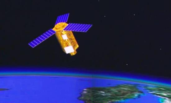
3月11日,据国内某权威媒体披露,由北京空间机电研究所自行研发的国内幅面最大,像元数最多、测绘精度最高的航空相机已顺利完成首次机载试飞成像任务,获得了令人满意的高清晰大视场图像,各项技术指标均居国际领先水平。该10亿像素级航空相机将大幅提升我国在航空摄影测量、资源遥感调查等领域的技术水平,填补我国在超大幅面航空测绘相机领域的研究空白,对提升我国对地观测能力和应急监测水平具有重要意义。军事观察家根据国内外公开资料对其做一背景解读。在普遍使用光学或雷达遥感卫星对敌进行情报侦察的今天, 传统的航空情报侦查工作依然占有重要的地位。由于航空侦察既可克服地面侦察受地球曲率和地形障碍物对视线的限制,又可弥补卫星侦察的细节和时效不足,所以目前它仍然是获取情报的最有效手段之一。
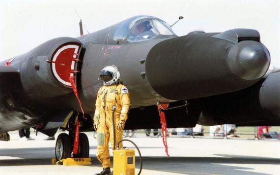
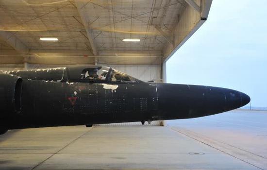
国外从20世纪初即开始研制以胶片为载体的航空侦察相机,至20世纪80年代,发达国家的胶片型航空相机已经非常成熟。但胶片型航空相机最大缺点是实时性较差,不能满足快节奏高技术战争的需要。从20世纪80年代开始,西方发达国家着手研发新一代CCD型实时传输航空侦察相机,并已研发成功多个型号。目前公开性能最先进的是在U-2S高空侦察机上使用的DB-110实时传输型相机,其可见光谱段分辨率达0.15米(距离50千米)。2013年5月,美国空军曾要求退役全部18架全球鹰无人侦察机、继续使用U-2S有人侦察机,在美军工业界乃至国会引发了轩然大波。美空军认为全球鹰不如U-2S重要原因之一就是U-2S的最大飞行高度达到27000米,较全球鹰的18000米要高出一半,但是U-2S相机侦察的距离更远,观察敌国边界线内侧最远可达180公里,而全球鹰仅能做到120公里左右。
像素是组成数字图像的最小单元,像素的个数越多,可挖掘的图像信息量越大,10亿像素级航空相机是上述传统成像仪的数十到数百倍,可以满足航天遥感、航空侦察、边海防预警、城市安防等领域对于大视场、远距离的高像素成像要求,具有极其重要的战略需求和广阔的市场应用前景 。据美国媒体报道,美国国防部先进项目研究局(DARPA)也正在资助基于无人侦察机的10亿像素级实时地面广域监视成像系统。该系统由4个完全相同的镜头和368个500万像素的探测器阵列拼接组成,当无人机在6000米高空飞行时可拍摄单张覆盖40平方公里的照片,最大输出像素为18亿,视场角为60°,可以精确监控地面上只有15厘米大小的物件,探测出地面行人所用的手机型号,同时定位跟踪65个动态目标。
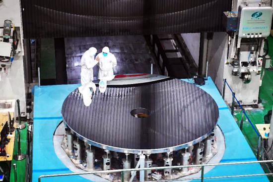
北京空间机电研究所是我国老牌空间光学遥感技术研制单位,先后自主研制并成功发射了170台卫星光学遥感器,所获取的信息资料广泛应用于国土普查、资源开发、环境监测、气象观测和国土测绘等各个领域。其研制的“高景一号”卫星相机是目前分辨率最高、质量最轻的商业遥感卫星用光学相机,其分辨率优于全色0.5米/多光谱2米,质量不超过200公斤,具有极其雄厚的研制实力。早在20世纪80年代,北京空间机电研究所就在国内首次把其研制的航天相机改造成高分辨率航空相机,获得了大量珍贵情报信息。其最新承研的10亿像素级航空相机具有拍摄快速、分辨率高、覆盖范围大等优点,能在一瞬间捕捉大量信息,可以广泛应用在航空大范围监视等领域,实现多目标同时监视 ,多用户同时对视场内感兴趣的区域进行观测、处理,共享同一操作终端。(作者署名:未来巡航者)
The success of the domestic 1 billion pixel camera can distinguish the ground pedestrian gender in space
The success of the domestic 1 billion pixel camera can distinguish the ground pedestrian gender in space
554
On March 11th, according to an authoritative media in China, the Beijing Aerospace Electromechanical Research Institute developed the largest domestic airborne camera with the largest number of elements and the highest accuracy of surveying and mapping, and successfully completed the first airborne test flight imaging mission. Satisfactory high-definition large-field image, all technical indicators are in the international leading level. The 1 billion-pixel aerial camera will greatly enhance China's technical level in the fields of aerial photogrammetry, resource remote sensing survey, etc., and fill the research gap in the field of ultra-large-format aerial mapping cameras in China, which will improve China's Earth observation capability and emergency monitoring level. Significance. Military observers make a background interpretation based on public information at home and abroad. Today, the use of optical or radar remote sensing satellites for intelligence reconnaissance of enemies, traditional aviation intelligence investigations still occupy an important position. Because aviation reconnaissance can overcome the limitation of ground reconnaissance by the curvature of the earth and the obstacles of the terrain obstacles, and can make up for the details and timeliness of satellite reconnaissance, it is still one of the most effective means of obtaining intelligence.
Foreign countries began to develop film-based aerial reconnaissance cameras from the early 20th century. By the 1980s, film-type aerial cameras in developed countries were very mature. However, the biggest drawback of film-type aerial cameras is their poor real-time performance, which cannot meet the needs of fast-paced high-tech warfare. Since the 1980s, Western developed countries have begun to develop a new generation of CCD-type real-time transmission aerial reconnaissance cameras, and have successfully developed several models. The most advanced public performance is the DB-110 real-time transmission camera used on the U-2S high-altitude reconnaissance aircraft, which has a visible spectral range resolution of 0.15 meters (distance 50 kilometers). In May 2013, the US Air Force had requested the retirement of all 18 Global Hawk unmanned reconnaissance aircraft and continued use of the U-2S manned reconnaissance aircraft, causing an uproar in the US military industry and even the Congress. The US Air Force believes that one of the important reasons why the Global Hawk is not as good as the U-2S is that the U-2S has a maximum flying height of 27,000 meters, which is half the height of the Global Hawk's 18,000 meters, but the U-2S camera reconnaissance is farther away, observing enemy borders. The inner side of the line can be as far as 180 kilometers, while the global eagle can only do about 120 kilometers.
Pixels are the smallest unit that constitutes a digital image. The more the number of pixels, the larger the amount of image information that can be mined. The 1 billion-pixel aerial camera is tens to hundreds of times more than the above-mentioned conventional imager, which can satisfy space remote sensing and aviation. Reconnaissance, border and coastal defense, urban security and other fields have extremely important strategic requirements and broad market application prospects for large field of view and long-range high-pixel imaging requirements. According to US media reports, the US Defense Advanced Research Projects Agency (DARPA) is also funding a 1 billion-pixel real-time terrestrial wide-area surveillance imaging system based on unmanned reconnaissance aircraft. The system consists of four identical lenses and 368 5 megapixel detector arrays. When the drone is flying at 6,000 meters, it can take a single photo covering 40 square kilometers, with a maximum output of 1.8 billion. With an angle of view of 60°, it is possible to accurately monitor objects on the ground that are only 15 cm in size, detect the type of mobile phone used by pedestrians on the ground, and locate and track 65 dynamic targets.
Beijing Space Electromechanical Research Institute is a research institute of China's old space optical remote sensing technology. It has independently developed and successfully launched 170 satellite optical remote sensors. The information obtained is widely used in national census, resource development, environmental monitoring, meteorological observation and land. Surveying and other fields. The "Gaojing No.1" satellite camera developed by it is the optical camera with the highest resolution and the lightest quality for commercial remote sensing satellites. Its resolution is better than full-color 0.5 m/multi-spectrum 2 m, and the quality is less than 200 kg. Extremely strong research and development strength. As early as in the 1980s, the Beijing Space Electromechanical Research Institute first transformed its space camera into a high-resolution aerial camera in China, and obtained a lot of valuable intelligence information. Its latest 100 million-pixel aerial camera has the advantages of fast shooting, high resolution, large coverage, and can capture a large amount of information in a flash. It can be widely used in a wide range of aviation surveillance and other fields to achieve multi-target simultaneous monitoring. Multiple users simultaneously observe and process the areas of interest in the field of view and share the same operation terminal. (Author's signature: future cruiser)
https://mil.news.sina.com.cn/jssd/2019-03-12/doc-ihrfqzkc3156803.shtml
国产10亿像素相机成功 可在太空分辨出地面行人性别
国产10亿像素相机成功 可在太空分辨出地面行人性别
554
3月11日,据国内某权威媒体披露,由北京空间机电研究所自行研发的国内幅面最大,像元数最多、测绘精度最高的航空相机已顺利完成首次机载试飞成像任务,获得了令人满意的高清晰大视场图像,各项技术指标均居国际领先水平。该10亿像素级航空相机将大幅提升我国在航空摄影测量、资源遥感调查等领域的技术水平,填补我国在超大幅面航空测绘相机领域的研究空白,对提升我国对地观测能力和应急监测水平具有重要意义。军事观察家根据国内外公开资料对其做一背景解读。在普遍使用光学或雷达遥感卫星对敌进行情报侦察的今天, 传统的航空情报侦查工作依然占有重要的地位。由于航空侦察既可克服地面侦察受地球曲率和地形障碍物对视线的限制,又可弥补卫星侦察的细节和时效不足,所以目前它仍然是获取情报的最有效手段之一。
国外从20世纪初即开始研制以胶片为载体的航空侦察相机,至20世纪80年代,发达国家的胶片型航空相机已经非常成熟。但胶片型航空相机最大缺点是实时性较差,不能满足快节奏高技术战争的需要。从20世纪80年代开始,西方发达国家着手研发新一代CCD型实时传输航空侦察相机,并已研发成功多个型号。目前公开性能最先进的是在U-2S高空侦察机上使用的DB-110实时传输型相机,其可见光谱段分辨率达0.15米(距离50千米)。2013年5月,美国空军曾要求退役全部18架全球鹰无人侦察机、继续使用U-2S有人侦察机,在美军工业界乃至国会引发了轩然大波。美空军认为全球鹰不如U-2S重要原因之一就是U-2S的最大飞行高度达到27000米,较全球鹰的18000米要高出一半,但是U-2S相机侦察的距离更远,观察敌国边界线内侧最远可达180公里,而全球鹰仅能做到120公里左右。
像素是组成数字图像的最小单元,像素的个数越多,可挖掘的图像信息量越大,10亿像素级航空相机是上述传统成像仪的数十到数百倍,可以满足航天遥感、航空侦察、边海防预警、城市安防等领域对于大视场、远距离的高像素成像要求,具有极其重要的战略需求和广阔的市场应用前景 。据美国媒体报道,美国国防部先进项目研究局(DARPA)也正在资助基于无人侦察机的10亿像素级实时地面广域监视成像系统。该系统由4个完全相同的镜头和368个500万像素的探测器阵列拼接组成,当无人机在6000米高空飞行时可拍摄单张覆盖40平方公里的照片,最大输出像素为18亿,视场角为60°,可以精确监控地面上只有15厘米大小的物件,探测出地面行人所用的手机型号,同时定位跟踪65个动态目标。
北京空间机电研究所是我国老牌空间光学遥感技术研制单位,先后自主研制并成功发射了170台卫星光学遥感器,所获取的信息资料广泛应用于国土普查、资源开发、环境监测、气象观测和国土测绘等各个领域。其研制的“高景一号”卫星相机是目前分辨率最高、质量最轻的商业遥感卫星用光学相机,其分辨率优于全色0.5米/多光谱2米,质量不超过200公斤,具有极其雄厚的研制实力。早在20世纪80年代,北京空间机电研究所就在国内首次把其研制的航天相机改造成高分辨率航空相机,获得了大量珍贵情报信息。其最新承研的10亿像素级航空相机具有拍摄快速、分辨率高、覆盖范围大等优点,能在一瞬间捕捉大量信息,可以广泛应用在航空大范围监视等领域,实现多目标同时监视 ,多用户同时对视场内感兴趣的区域进行观测、处理,共享同一操作终端。(作者署名:未来巡航者)
The success of the domestic 1 billion pixel camera can distinguish the ground pedestrian gender in space
The success of the domestic 1 billion pixel camera can distinguish the ground pedestrian gender in space
554
On March 11th, according to an authoritative media in China, the Beijing Aerospace Electromechanical Research Institute developed the largest domestic airborne camera with the largest number of elements and the highest accuracy of surveying and mapping, and successfully completed the first airborne test flight imaging mission. Satisfactory high-definition large-field image, all technical indicators are in the international leading level. The 1 billion-pixel aerial camera will greatly enhance China's technical level in the fields of aerial photogrammetry, resource remote sensing survey, etc., and fill the research gap in the field of ultra-large-format aerial mapping cameras in China, which will improve China's Earth observation capability and emergency monitoring level. Significance. Military observers make a background interpretation based on public information at home and abroad. Today, the use of optical or radar remote sensing satellites for intelligence reconnaissance of enemies, traditional aviation intelligence investigations still occupy an important position. Because aviation reconnaissance can overcome the limitation of ground reconnaissance by the curvature of the earth and the obstacles of the terrain obstacles, and can make up for the details and timeliness of satellite reconnaissance, it is still one of the most effective means of obtaining intelligence.
Foreign countries began to develop film-based aerial reconnaissance cameras from the early 20th century. By the 1980s, film-type aerial cameras in developed countries were very mature. However, the biggest drawback of film-type aerial cameras is their poor real-time performance, which cannot meet the needs of fast-paced high-tech warfare. Since the 1980s, Western developed countries have begun to develop a new generation of CCD-type real-time transmission aerial reconnaissance cameras, and have successfully developed several models. The most advanced public performance is the DB-110 real-time transmission camera used on the U-2S high-altitude reconnaissance aircraft, which has a visible spectral range resolution of 0.15 meters (distance 50 kilometers). In May 2013, the US Air Force had requested the retirement of all 18 Global Hawk unmanned reconnaissance aircraft and continued use of the U-2S manned reconnaissance aircraft, causing an uproar in the US military industry and even the Congress. The US Air Force believes that one of the important reasons why the Global Hawk is not as good as the U-2S is that the U-2S has a maximum flying height of 27,000 meters, which is half the height of the Global Hawk's 18,000 meters, but the U-2S camera reconnaissance is farther away, observing enemy borders. The inner side of the line can be as far as 180 kilometers, while the global eagle can only do about 120 kilometers.
Pixels are the smallest unit that constitutes a digital image. The more the number of pixels, the larger the amount of image information that can be mined. The 1 billion-pixel aerial camera is tens to hundreds of times more than the above-mentioned conventional imager, which can satisfy space remote sensing and aviation. Reconnaissance, border and coastal defense, urban security and other fields have extremely important strategic requirements and broad market application prospects for large field of view and long-range high-pixel imaging requirements. According to US media reports, the US Defense Advanced Research Projects Agency (DARPA) is also funding a 1 billion-pixel real-time terrestrial wide-area surveillance imaging system based on unmanned reconnaissance aircraft. The system consists of four identical lenses and 368 5 megapixel detector arrays. When the drone is flying at 6,000 meters, it can take a single photo covering 40 square kilometers, with a maximum output of 1.8 billion. With an angle of view of 60°, it is possible to accurately monitor objects on the ground that are only 15 cm in size, detect the type of mobile phone used by pedestrians on the ground, and locate and track 65 dynamic targets.
Beijing Space Electromechanical Research Institute is a research institute of China's old space optical remote sensing technology. It has independently developed and successfully launched 170 satellite optical remote sensors. The information obtained is widely used in national census, resource development, environmental monitoring, meteorological observation and land. Surveying and other fields. The "Gaojing No.1" satellite camera developed by it is the optical camera with the highest resolution and the lightest quality for commercial remote sensing satellites. Its resolution is better than full-color 0.5 m/multi-spectrum 2 m, and the quality is less than 200 kg. Extremely strong research and development strength. As early as in the 1980s, the Beijing Space Electromechanical Research Institute first transformed its space camera into a high-resolution aerial camera in China, and obtained a lot of valuable intelligence information. Its latest 100 million-pixel aerial camera has the advantages of fast shooting, high resolution, large coverage, and can capture a large amount of information in a flash. It can be widely used in a wide range of aviation surveillance and other fields to achieve multi-target simultaneous monitoring. Multiple users simultaneously observe and process the areas of interest in the field of view and share the same operation terminal. (Author's signature: future cruiser)